Category:Gambier Terrace
| Object location | | View all coordinates using: OpenStreetMap |
|---|
street in Liverpool, England, UK .JPG) | |||||
| Upload media | |||||
| Instance of | |||||
|---|---|---|---|---|---|
| Location | Liverpool, Merseyside, North West England, England | ||||
 | |||||
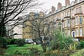
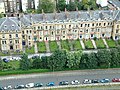
Gambier Terrace (Liverpool, England) is a row of magnificent Georgian houses situated on a 'terrace' located in the Canning Georgian Quarter of Liverpool city centre, overlooking St. James Mount and Gardens and Liverpool Cathedral it was named after James Gambier. From number 1 to 10 are Grade II* Listed Buildings. They were designed by John Foster. Together with Hope Street and Rodney Street it forms the Rodney Street conservation area.
Subcategories
This category has the following 2 subcategories, out of 2 total.
1
G
Media in category "Gambier Terrace"
The following 8 files are in this category, out of 8 total.
-
 Gambier Terrace From South end.JPG 1,840 × 1,232; 1.34 MB
-
 Gambier Terrace, Liverpool (1).JPG 4,320 × 3,240; 3.05 MB
-
 Gambier Terrace, Liverpool (2).JPG 4,320 × 3,240; 3.58 MB
-
 Gambier Terrace, Liverpool (3).JPG 4,320 × 3,240; 3.9 MB
-
 Gambier Terrace, Liverpool (4).JPG 4,320 × 3,240; 3.75 MB
-
 Gambier Terrace.jpg 640 × 480; 161 KB
-
 Looking towards the rear of Gambier Terrace from Huskisson Street (1).JPG 3,240 × 4,320; 3.28 MB
-
 Looking towards the rear of Gambier Terrace from Huskisson Street (2).JPG 3,240 × 4,320; 3.21 MB

.JPG)
.JPG)
.JPG)

.JPG)
.JPG)