Category:Gare de Nogent-le-Rotrou
| Object location | | View all coordinates using: OpenStreetMap |
|---|
railway station in Nogent-le-Rotrou, France  | |||||
| Upload media | |||||
| Instance of | |||||
|---|---|---|---|---|---|
| Location | Nogent-le-Rotrou, Eure-et-Loir, Centre-Val de Loire, Metropolitan France, France | ||||
| Transport network | |||||
| Owned by | |||||
| Operator | |||||
| Date of official opening |
| ||||
| Elevation above sea level |
| ||||
| Connecting line | |||||
| Adjacent station | |||||
 | |||||
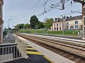
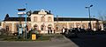
Français : La gare de Nogent-le-Rotrou est une gare ferroviaire française de la ligne de Paris-Montparnasse à Brest, située sur le territoire de la commune de Nogent-le-Rotrou, dans le département d'Eure-et-Loir, en région Centre.
Media in category "Gare de Nogent-le-Rotrou"
The following 14 files are in this category, out of 14 total.
-
 Gare de nogent le rotrou - panoramio.jpg 2,560 × 1,920; 1.16 MB
-
 Gare de Nogent-le-Rotrou (28).JPG 2,048 × 1,536; 988 KB
-
 Gare de Nogent-le-Rotrou - Rénovation Quai 1 avec TER N°16766 en direction de Paris.jpg 4,624 × 3,468; 5.02 MB
-
 Gare de Nogent-le-Rotrou - Rénovation Quai 1.jpg 4,624 × 3,468; 5.61 MB
-
 Gare de Nogent-le-Rotrou - Rénovation Quai 2 avec TER N°16766 en direction de Paris.jpg 3,468 × 4,624; 6.07 MB
-
 Gare de Nogent-le-Rotrou signaletique.jpg 2,592 × 1,944; 1.21 MB
-
 Nogent-le-Rotrou - Train station - 1.jpg 5,184 × 2,376; 2.04 MB
-
 Nogent-le-Rotrou - Train station - 2.jpg 5,184 × 3,456; 2.42 MB
-
 Nogent-le-Rotrou - Train station - 3.JPG 5,184 × 3,456; 2.61 MB
-
 Nogent-le-Rotrou - Train station - 4.JPG 4,784 × 2,152; 1.74 MB
-
 Nogent-le-Rotrou - Train station - 5.JPG 4,640 × 2,664; 2.89 MB
-
 Nogent-le-Rotrou - Train station - 6.JPG 4,472 × 2,696; 2.76 MB
-
 Nogent-le-Rotrou - Train station - 7.JPG 5,184 × 3,088; 3.22 MB
-
 Nogent-le-Rotrou - Train station - 8.JPG 4,352 × 2,352; 2.29 MB

.JPG)


