Category:Garrison Creek
watercourse in Ontario, Canada  | |||||
| Upload media | |||||
| Instance of | |||||
|---|---|---|---|---|---|
| Location | Ontario, Canada | ||||
| Elevation above sea level |
| ||||
 | |||||
Media in category "Garrison Creek"
The following 23 files are in this category, out of 23 total.
-

-
 Brick sewer, south of Bloor, 1915.jpg 2,924 × 1,988; 382 KB
-
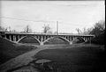
 Bridge at Harbord, over Garrison Creek, Toronto.jpg 2,952 × 1,672; 347 KB
-

-
 CrawfordStreetBridge1915.jpg 1,050 × 719; 133 KB
-
 Digging a sewer along Garrison Creek in the 1890s.jpg 1,050 × 817; 569 KB
-
 Fort York and the lower reaches of Garrison Creek.jpg 544 × 535; 111 KB
-
-
 FortYork1804.jpg 540 × 302; 34 KB
-

-
 Hikers on the bank of Garrison Creek.jpg 1,280 × 852; 291 KB
-
 Lower course of Garrison Creek, 1818.jpg 185 × 204; 34 KB
-
 Lower course of Garrison Creek, Toronto, 1851.jpg 700 × 971; 176 KB
-
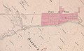
 Map of Garrison Creek, late 1800s.jpg 291 × 466; 67 KB
-
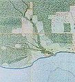
 Map of lower reaches of Garrison Creek, Toronto.jpg 590 × 839; 209 KB
-
 Plan of the fort at York, no. 24. E.W. Durnford, Sept 24, 1823..jpeg 3,088 × 2,978; 1.86 MB
-
 Plan of York, no. 24, See General Plan of the Canadies (y) E.W. Durnford, 1823-09-24.jpg 1,754 × 1,920; 1.13 MB
-

-

-
 Possibly Garrison Creek, in 1907.jpg 2,976 × 2,108; 418 KB
-

-
 Upper Canada's Fort York and the lower reaches of Garrison Creek.jpg 820 × 772; 264 KB
-
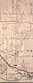 Watershed of Garrison Creek, 1878.jpg 1,148 × 2,904; 2.21 MB


_E.W._Durnford,_Sept_24,_1823_(rotated_49_degrees).jpg)


_E.W._Durnford,_1823-09-24.jpg)
_E.W._Durnford,_Sept_24,_1823_(rotated_30_degrees_to_restore_true_north).jpg)
_E.W._Durnford,_Sept_24,_1823.jpg)


