Category:Gasthuisstraat 11, Doesburg
| Object location | | View all coordinates using: OpenStreetMap |
|---|
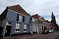
building in Doesburg, Netherlands  | |||||
| Upload media | |||||
| Instance of | |||||
|---|---|---|---|---|---|
| Location | Doesburg, Gelderland, Netherlands | ||||
| Street address |
| ||||
| Located on street | |||||
| Heritage designation |
| ||||
 | |||||
|
This is a category about rijksmonument number 12958
|
| Address |
|
Media in category "Gasthuisstraat 11, Doesburg"
The following 9 files are in this category, out of 9 total.
-
 Doesburg, Netherlands - panoramio (155).jpg 2,048 × 1,155; 584 KB
-
 Doesburg, Netherlands - panoramio (22).jpg 1,375 × 2,048; 436 KB
-
 Doesburg, Netherlands - panoramio (8).jpg 2,048 × 1,375; 581 KB
-
 Doesburg, Netherlands - panoramio (86).jpg 4,896 × 3,264; 2.2 MB
-
 Gasthuisstraat 11 Doesburg.jpg 2,010 × 1,518; 883 KB
-
 Gedeelte noord wand - Doesburg - 20058115 - RCE.jpg 1,200 × 800; 179 KB
-
 Gedeelte zuid wand - Doesburg - 20058114 - RCE.jpg 1,200 × 800; 170 KB
-
 Voorgevel - Doesburg - 20058131 - RCE.jpg 810 × 1,200; 160 KB
-
 Winterstreetview 13 December Doesburg - panoramio.jpg 3,648 × 2,432; 1.91 MB
.jpg)
.jpg)
.jpg)
.jpg)


