Category:Gattendorf
municipality of Germany     | |||||
| Upload media | |||||
| Instance of |
| ||||
|---|---|---|---|---|---|
| Part of |
| ||||
| Location |
| ||||
| Head of government |
| ||||
| Population |
| ||||
| Area |
| ||||
| Elevation above sea level |
| ||||
| Different from | |||||
| official website | |||||
 | |||||
See also: Category:Gattendorf, Burgenland
Subcategories
This category has the following 5 subcategories, out of 5 total.
B
C
S
Media in category "Gattendorf"
The following 6 files are in this category, out of 6 total.
-
 Wappen Gattendorf OF.png 150 × 160; 71 KB
-
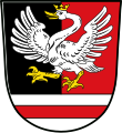 Wappen von Gattendorf.svg 702 × 764; 170 KB
-
 Digitales Orthofoto von Gattendorf (Bayerische Vermessungsverwaltung).tif 17,500 × 17,500; 652.51 MB
-
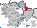
 Gattendorf im Landkreis Hof.png 613 × 489; 95 KB
-
 Gattendorf in HO.svg 642 × 501; 1.27 MB
-
 Kirchgattendorf von Osten 2011.jpg 3,000 × 2,000; 1.02 MB

