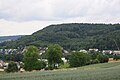
Category:Gebenstorfer Horn
| Object location | | View all coordinates using: OpenStreetMap |
|---|
Archaeological site in Gebenstorf in the canton of Aargau, Switzerland  | |||||
| Upload media | |||||
| Instance of | |||||
|---|---|---|---|---|---|
| Part of | |||||
| Location | Gebenstorf, Baden District, Aargau, Switzerland | ||||
| Street address |
| ||||
| Heritage designation | |||||
| Elevation above sea level |
| ||||
 | |||||
Media in category "Gebenstorfer Horn"
The following 13 files are in this category, out of 13 total.
-
 ETH-BIB-Gebenstorfer Horn und Reuss von Windisch-Dia 247-13234.tif 3,653 × 2,798; 29.39 MB
-
 ETH-BIB-Gebenstorfer Horn, Deckenschotter an der West-Kante-Dia 247-13232.tif 2,929 × 3,439; 28.96 MB
-
 ETH-BIB-Gebenstorfer Horn, Deckenschotter an der Westkante-Dia 247-13233.tif 3,006 × 3,433; 9.97 MB
-
 ETH-BIB-Gebenstorfer Horn, Panorama nach Westen (Reuss-Aare)-Dia 247-13231.tif 3,640 × 2,803; 9.83 MB
-
 ETH-BIB-Gebenstorfer Horn, Panorama Nordost-Dia 247-13229.tif 3,633 × 2,734; 9.59 MB
-
 ETH-BIB-Gebenstorfer Horn, Panorama Nordwest-Dia 247-13230.tif 3,649 × 2,729; 28.62 MB
-
 ETH-BIB-Gebenstorfer Horn-Panorama nach Norden (N)-Dia 247-13228.tif 3,645 × 2,729; 28.61 MB
-
 Gebenstorfer Horn 1443.jpg 3,888 × 2,592; 3.53 MB
-
 Gebenstorfer Horn 2723.jpg 3,888 × 2,592; 5.66 MB
-
 Gebenstorfer Horn Jura- Höhenweg.jpg 1,944 × 2,592; 2.6 MB
-
 Gebenstorfer Horn Wanderweg E4.jpg 2,048 × 1,536; 678 KB
-
 Gebenstorfer Horn.jpg 2,816 × 2,112; 1.85 MB
-
 Reisfeld Unterau Gebenstorfer Horn.jpg 2,560 × 1,920; 1.26 MB


