Category:Gemeente Atlas van Nederland - Limburg
Media in category "Gemeente Atlas van Nederland - Limburg"
The following 17 files are in this category, out of 17 total.
-
 Provlimburg.gif 1,600 × 2,551; 266 KB
-
 1867 Belfeld, Gemeente Atlas van Nederland.jpg 900 × 1,134; 330 KB
-
 Netherlands, Ambij (Amby, Maastricht), map of 1866.jpg 1,180 × 1,014; 224 KB
-
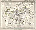
 Arcen en Velden, Gemeenteatlas van Nederland.jpg 1,227 × 1,600; 562 KB
-
 Bemelen, Netherlands, 1866.jpg 1,572 × 1,380; 591 KB
-
 Borgharen.jpg 1,214 × 1,505; 236 KB
-
 Cadier.gif 1,600 × 1,452; 280 KB
-
 Herkenbosch.gif 1,600 × 1,265; 207 KB
-
 Itteren ca. 1870.jpg 1,024 × 879; 141 KB
-
 Nederweert, Gemeenteatlas van Nederland.png 792 × 666; 836 KB
-
 Netherlands, Rimburg, Map of 1866.PNG 1,377 × 1,214; 2.89 MB
-
 Rijckholt, Gemeenteatlas van Nederland.jpg 1,640 × 1,239; 804 KB
-

-
 Sint Geertruid, Gemeenteatlas van Nederland.jpg 1,427 × 1,148; 671 KB
-
 1867 Tegelen.jpg 1,483 × 1,639; 1.52 MB
-
 Venlo, Gemeenteatlas van Nederland.jpg 2,018 × 2,678; 1.54 MB
-
 Wijnandsrade1866.jpg 1,246 × 1,031; 662 KB


,_map_of_1866.jpg)


