Category:Gemeenteweg 215, Staphorst
| Object location | | View all coordinates using: OpenStreetMap |
|---|
 | |||||
| Upload media | |||||
| Instance of | |||||
|---|---|---|---|---|---|
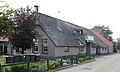
| Location | Staphorst, Overijssel, Netherlands | ||||
| Street address |
| ||||
| Located on street |
| ||||
| Heritage designation |
| ||||
 | |||||
|
This is a category about rijksmonument number 34216
|
| Address |
|
Media in category "Gemeenteweg 215, Staphorst"
The following 4 files are in this category, out of 4 total.
-
 Aanzicht - Staphorst - 20204124 - RCE.jpg 1,191 × 1,200; 365 KB
-
 Rechter zij- en achtergevel - Staphorst - 20204126 - RCE.jpg 1,200 × 1,200; 273 KB
-
 Staphorst - Gemeenteweg 215 RM34216.JPG 4,530 × 2,700; 1.14 MB
-
 Voor- en rechter zijgevel - Staphorst - 20204125 - RCE.jpg 1,200 × 1,183; 287 KB


