Category:Geography of Gotemba
Wikimedia category | |||||
| Upload media | |||||
| Instance of | |||||
|---|---|---|---|---|---|
| |||||
日本語: 静岡県御殿場市の地理。
Subcategories
This category has the following 11 subcategories, out of 11 total.
Media in category "Geography of Gotemba"
The following 22 files are in this category, out of 22 total.
-
 2000年 Japan 日本御殿場市 富士仏舎利塔平和公園 妙法寺 - panoramio.jpg 852 × 564; 472 KB
-
 A street in Gotemba.jpg 3,072 × 2,304; 3.52 MB
-
 Fujiyama, from Otometoge (3109864797).jpg 760 × 630; 41 KB
-
 Gotemba city center area Aerial photograph.1983.jpg 5,891 × 3,499; 14.4 MB
-
 Gotemba Root and Akaiwahachigokan.jpg 6,000 × 4,000; 8.4 MB
-
 Gotenba in Shizuoka Prefecture Ja.svg 571 × 446; 11 KB
-
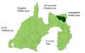 Gotenba in Shizuoka Prefecture.png 1,281 × 801; 44 KB
-
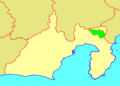
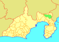 GotenbaShizuokaMap.png 320 × 230; 7 KB
-
 Hakone from gotemba.jpg 6,151 × 909; 1.35 MB
-
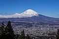
 Mount Fuji from Mount Kintoki 2022-11-22.jpg 6,000 × 4,000; 5.7 MB
-
 Mt.FUJI 富士山 20131212 07.jpg 4,896 × 2,752; 3.04 MB
-
 Otome toge kara no Fuji san to Gotemba no Machinami 20200217.jpg 6,000 × 4,000; 10.07 MB
-
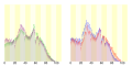 Population distribution of Gotemba, Shizuoka, Japan.svg 512 × 256; 22 KB
-
 Street view of Gotemba, Shizuoka near Gotemba Station 1.jpg 2,448 × 3,264; 3.46 MB
-
 Street view of Gotemba, Shizuoka near Gotemba Station 3.JPG 3,264 × 2,448; 2.71 MB
-
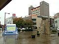 View in front of Fujisan Entrance of Gotemba Station.JPG 3,264 × 2,448; 2.08 MB
-
 View of gotemba.jpg 1,600 × 1,200; 803 KB
-
 国道246号御殿場001.jpg 400 × 300; 53 KB
-
 地図-静岡県御殿場市-2006.png 320 × 230; 4 KB
-
 太郎坊洞門 - panoramio.jpg 4,000 × 3,000; 7.66 MB
-
 御殿場地デジ中継局.jpg 960 × 1,280; 230 KB
-
 長尾丸山ハイキングコース - panoramio.jpg 1,600 × 1,200; 566 KB


.jpg)


