Category:Geological maps of Thuringia
Federal states of Germany:
Subcategories
This category has only the following subcategory.
G
- Geological maps of Eichsfeld (6 F)
Media in category "Geological maps of Thuringia"
The following 18 files are in this category, out of 18 total.
-
 Geolog.thueringen.jpg 800 × 625; 203 KB
-
 429 of 'Thüringen. Ein geographisches Handbuch, etc' (11215743973).jpg 5,138 × 5,010; 7.3 MB
-
 Geologische Karte Auersberger Kuppenrhoen.jpg 363 × 615; 52 KB
-
 Geologische Karte Brueckenauer Kuppenrhoen.jpg 379 × 518; 45 KB
-
 Geologische Karte Hochrhoen.jpg 369 × 815; 73 KB
-
 Geologische Karte Milseburger Kuppenrhoen.jpg 380 × 620; 58 KB
-
 Geologische Karte Oestliches Rhoenvorland.jpg 419 × 381; 40 KB
-
 Geologische Karte Rhoen.jpg 800 × 971; 272 KB
-
 Geologische Karte Soisberger Kuppenrhoen.jpg 380 × 596; 46 KB
-
 Geologische Karte Ulstertal.jpg 368 × 777; 69 KB
-
 Geologische Karte Vorderrhoen.jpg 337 × 670; 41 KB
-
 Geomap Muenchberg Massif.png 2,470 × 2,883; 1.99 MB
-
 Geomap Rhoen.jpg 3,549 × 3,692; 2.69 MB
-
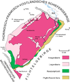
 Geomap Thur-Franc-Vogtl-SM.png 3,261 × 2,205; 2.49 MB
-
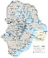
 Thueringer Becken - geologische Struktur.jpg 1,352 × 1,181; 389 KB
-
 Thueringer Becken - Schollengliederung.jpg 1,349 × 1,019; 295 KB
-
 Thueringer Becken - Stoerungen.jpg 1,337 × 1,184; 417 KB
-
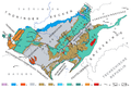
 Thuringian Forest Geology.png 3,226 × 2,501; 2.19 MB

.jpg)


