Category:Geotop Einsiedlerfels bei Pucher
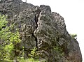
Deutsch: Der Einsiedlerfels bei Pucher ist eine Felskuppe im Landkreis Cham in der Oberpfalz in Bayern. Sie ist als Geotop (372R030) und Naturdenkmal ausgewiesen.
 | |||||
| Upload media | |||||
| Instance of | |||||
|---|---|---|---|---|---|
| Location | Waldmünchen, Cham, Upper Palatinate, Bavaria, Germany | ||||
| Heritage designation | |||||
| Width |
| ||||
| Length |
| ||||
| Area |
| ||||
| Elevation above sea level |
| ||||
| official website | |||||
 | |||||
This category shows the natural monument in Herzogau in Bavaria with the ID ND-02701 and the name Einsiedlerfels bei der Ortschaft Pucher.
|
 |
 |
Media in category "Geotop Einsiedlerfels bei Pucher"
The following 13 files are in this category, out of 13 total.
-
 WaldmuenchenPucherEinsiedlerfels 01.JPG 2,304 × 1,704; 868 KB
-
 WaldmuenchenPucherEinsiedlerfels 02.JPG 2,304 × 1,704; 890 KB
-
 WaldmuenchenPucherEinsiedlerfels 03.JPG 2,304 × 1,704; 894 KB
-
 WaldmuenchenPucherEinsiedlerfels 04.JPG 2,304 × 1,704; 890 KB
-
 WaldmuenchenPucherEinsiedlerfels 05.JPG 2,304 × 1,704; 851 KB
-
 WaldmuenchenPucherEinsiedlerfels 06.JPG 2,304 × 1,704; 888 KB
-
 WaldmuenchenPucherEinsiedlerfels 07.JPG 2,304 × 1,704; 902 KB
-
 WaldmuenchenPucherEinsiedlerfels 08.JPG 2,304 × 1,704; 871 KB
-
 WaldmuenchenPucherEinsiedlerfels 09.JPG 2,304 × 1,704; 915 KB
-
 WaldmuenchenPucherEinsiedlerfels 10.JPG 2,304 × 1,704; 920 KB
-
 WaldmuenchenPucherEinsiedlerfels 11.JPG 2,304 × 1,704; 887 KB
-
 WaldmuenchenPucherEinsiedlerfels 12.JPG 2,304 × 1,704; 903 KB
-
 WaldmuenchenPucherEinsiedlerfels 13.JPG 2,304 × 1,704; 935 KB


