Category:German-language maps of China
Media in category "German-language maps of China"
The following 19 files are in this category, out of 19 total.
-
 Shanghai ca 1910.JPG 1,027 × 979; 455 KB
-
 Beijing 1875 Vicinity DE.jpg 8,047 × 5,312; 6.81 MB
-
 Beijing 1878 DE.jpg 4,710 × 6,660; 5.49 MB
-
 Beijing 1907 Vicinity DE.jpg 8,772 × 10,178; 13.81 MB
-
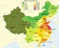 Bevoelkerungsdichte Chinesischer Provinzen.png 1,042 × 852; 71 KB
-
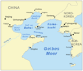 Bohaiseamap2 de.png 583 × 500; 150 KB
-
 China administrative (deutsch).png 857 × 699; 85 KB
-
 China national high speed rail grid 8 8 de status Jan 2022.svg 1,000 × 850; 215 KB
-
 China national high speed rail grid 8 8 de.svg 1,000 × 850; 195 KB
-
 Csl football 2010 teams de.png 2,131 × 1,759; 327 KB
-

-
 Image-Qingdao city map 1912 in german.png 1,585 × 1,184; 961 KB
-
 Lage des Mount Everest.PNG 500 × 599; 144 KB
-
 Lhasa Lage.jpg 379 × 295; 34 KB
-
 Map of sinitic languages full-de.svg 1,775 × 1,407; 126 KB
-
 Map of the South–North Water Transfer Project in China (de).png 2,340 × 1,199; 646 KB
-
 Ningxia province.png 318 × 418; 29 KB
-
 ROC Administrative and Claims-de.png 1,691 × 1,251; 281 KB
-
 Schantung Kiautschou.jpg 1,044 × 844; 177 KB


.png)


_und_das_Kaiserthum_Japan.jpg)


.png)