Category:Gipfelkapelle Ottmanach, Magdalensberg
| Object location | | View all coordinates using: OpenStreetMap |
|---|
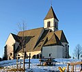
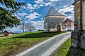
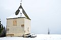
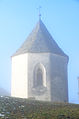
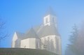
building in Magdalensberg, Austria  | |||||
| Upload media | |||||
| Instance of | |||||
|---|---|---|---|---|---|
| Location | Magdalensberg, Klagenfurt-Land District, Carinthia, Austria | ||||
| Heritage designation | |||||
 | |||||
Media in category "Gipfelkapelle Ottmanach, Magdalensberg"
The following 28 files are in this category, out of 28 total.
-
 Helberg Kirche 24122006 06.jpg 2,676 × 2,340; 1.07 MB
-
 Magdalensberg Filialkirche hll Helena und Maria Magdalena SO-Ansicht 22122015 9778.jpg 7,360 × 4,912; 20.59 MB
-
 Magdalensberg Wolfgangkapelle N-Ansicht 15042022 2476.jpg 6,412 × 4,912; 13.62 MB
-
 Magdalensberg Wolfgangkapelle N-Ansicht 29032023 3707.jpg 7,021 × 4,686; 25.91 MB
-
 Magdalensberg Wolfgangkapelle N-Ansicht 29032023 3708.jpg 7,360 × 4,912; 28.32 MB
-
 Magdalensberg Wolfgangkapelle Portal 15042022 2481.jpg 4,912 × 7,360; 28.52 MB
-
 Magdalensberg Wolfgangkapelle SO-Ansicht 15042022 2489.jpg 4,912 × 7,360; 23.34 MB
-

-

-

-
 Magdalensberg Wolfgangkapelle W-Wand Fresko hl. Wolfgang 15042022 2482.jpg 4,283 × 5,806; 19.96 MB
-
 Magdalensberg Wolfgangkapelle W-Wand Fresko hl. Wolfgang 22122015 9784.jpg 4,413 × 6,097; 21.27 MB
-
 Magdalensberg Wolfgangskapelle NW-Ansicht 04042013 4085.jpg 3,264 × 4,928; 1.32 MB
-

-
 Wolfgangskapelle Fresko Heiliger Wolfgang 12122013 339.jpg 3,264 × 4,928; 11.43 MB
-
 Magdalensberg Gipfelkirche Ostansicht 20122007 07.jpg 1,584 × 1,602; 679 KB
-
 Magdalensberg Ottmanach Gipfelkapelle Fresko Heiliger Wolfgang 20122007 331.jpg 2,268 × 3,335; 1.62 MB
-
 Magdalensberg Ottmanach Gipfelkapelle Nordansicht 20122007 333.jpg 1,284 × 1,889; 348 KB
-
 Magdalensberg Ottmanach Gipfelkapelle Suedansicht 20122007 334.jpg 2,592 × 3,872; 1.39 MB
-
 Magdalensberg Wallfahrtskirche hll Helena und Maria Magdalena SW-Ansicht 12122013 355.jpg 4,928 × 3,264; 10.8 MB
-
 Magdalensberg Wolfgangskapelle 04042013 087.jpg 3,264 × 4,928; 1.35 MB
-
 Magdalensberg Wolfgangskapelle 04042013 088.jpg 4,928 × 3,264; 983 KB
-
 Magdalensberg Wolfgangskapelle 12122013 326.jpg 3,264 × 4,928; 8.96 MB
-
 Magdalensberg Wolfgangskapelle 12122013 328.jpg 4,928 × 3,264; 10.02 MB
-
 Magdalensberg Wolfgangskapelle Fresko heiliger Wolfgang 04042013 092.jpg 3,264 × 4,928; 2.27 MB
-
 Magdalensberg Wolfgangskapelle mit Chor der Helenenkirche 04042013 083.jpg 4,928 × 3,264; 1.45 MB
-
 Wolfgangskapelle und Wallfahrtskirche Heilige Helena und Maria Magdalena 12122013 322.jpg 4,928 × 3,264; 8.56 MB
-
 Wolfgangskapelle und Wallfahrtskirche Heilige Helena und Maria Magdalena 12122013 323.jpg 3,264 × 4,928; 8.43 MB


