Category:Glenmalure, County Wicklow
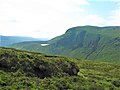
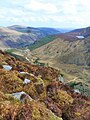
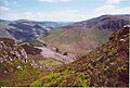
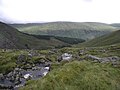
English: Glenmalure (Irish: Gleann Molúra) is a U-shaped glacial valley in the Wicklow Mountains in Ireland.
Glacial valley in Wicklow, Ireland  | |||||
| Upload media | |||||
| Instance of | |||||
|---|---|---|---|---|---|
| Location | County Wicklow, Leinster, Ireland | ||||
| Located in or next to body of water | |||||
| Width |
| ||||
| Length |
| ||||
| Height |
| ||||
| Mountain range | |||||
| Origin of the watercourse | |||||
 | |||||
Media in category "Glenmalure, County Wicklow"
The following 52 files are in this category, out of 52 total.
-
-
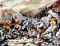 2--battle-of-glenmalure-1580-wicklow-val-byrne.jpg 900 × 700; 235 KB
-
 Arts Lough from Benleagh II.jpg 700 × 525; 78 KB
-
 Arts Lough from Benleagh III.jpg 300 × 296; 30 KB
-
 Arts Lough from Benleagh.jpg 450 × 600; 37 KB
-
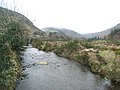
 Avonbeg River in Glenmalure, Co. Wicklow - geograph.org.uk - 1217203.jpg 640 × 480; 148 KB
-
 Avonbeg River in Glenmalure, Co. Wicklow - geograph.org.uk - 1217208.jpg 640 × 480; 144 KB
-
 Avonbeg River in Glenmalure, Co. Wicklow - geograph.org.uk - 1217214.jpg 640 × 480; 138 KB
-
 Avonberg à Glenmalure.jpg 1,098 × 1,734; 588 KB
-
 Carrawaystick Brook, Glenmalure - geograph.org.uk - 290240.jpg 1,712 × 2,288; 822 KB
-
 Carrawaystick River Glen, Glenmalure, Wicklow.jpg 4,389 × 2,990; 4.43 MB
-
 Carrawaystick River, Glenmalure, Wicklow.jpg 3,240 × 4,908; 2.19 MB
-
 Cliffs of Benleagh II.jpg 910 × 604; 552 KB
-
 Cloghernagh and Arts Lough II.jpg 400 × 271; 15 KB
-
 Cloghernagh and Arts Lough.jpg 910 × 604; 402 KB
-
 Crusher House, Glenmalure, Wicklow.jpg 3,264 × 4,928; 6.06 MB
-
 Descending into Glenmalure, Co. Wicklow - geograph.org.uk - 1310707.jpg 640 × 480; 144 KB
-
 Disused crusher house, Glenmalure, Wicklow.jpg 4,906 × 3,243; 6.65 MB
-

-
 Forestry road in Glenmalure, Co. Wicklow - geograph.org.uk - 1217195.jpg 640 × 480; 143 KB
-
 Fraughan Rock Glen - geograph.org.uk - 290239.jpg 2,288 × 1,712; 655 KB
-
 Fraughan Rock Glen.jpg 1,200 × 560; 263 KB
-
 Glenmalure - geograph.org.uk - 627453.jpg 640 × 480; 105 KB
-
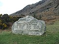 Glenmalure Memorial.jpg 2,272 × 1,704; 924 KB
-
 Glenmalure Valley, Co. Wicklow - geograph.org.uk - 1217206.jpg 640 × 480; 138 KB
-
 Glenmalure Valley, Wicklow.jpg 3,008 × 2,000; 2.9 MB
-
 Glenmalure.jpg 2,048 × 1,152; 537 KB
-
 Glenmalure1.jpg 1,152 × 2,048; 551 KB
-
 Hill walking in Glenmalure, Co Wicklow 01.jpg 1,004 × 1,024; 579 KB
-
 Hill walking in Glenmalure, Co Wicklow 02.jpg 992 × 1,024; 587 KB
-
 Hill walking in Glenmalure, Co Wicklow 03.jpg 992 × 1,028; 580 KB
-
 Hill walking in Glenmalure, Co Wicklow 04.jpg 996 × 1,024; 596 KB
-
 Hill walking in Glenmalure, Co Wicklow 05.jpg 996 × 1,024; 681 KB
-
 Hill walking in Glenmalure, Co Wicklow 06.jpg 992 × 1,024; 546 KB
-
 In Glenmalure (NBY 438815).jpg 3,600 × 2,296; 2.09 MB
-
 In Glenmalure (NBY 439298).jpg 3,600 × 2,314; 2.28 MB
-
 In Glenmalure (NBY 439442).jpg 3,600 × 2,310; 2.17 MB
-
 Lugduff from Camenabologue.jpg 896 × 503; 40 KB
-
 Lugnaquilla from Fraughan Rock Glen (Wicklow, Ireland).jpg 640 × 479; 67 KB
-
 Lugnaquilla from Glenmalure.jpg 4,288 × 2,412; 4.43 MB
-

-
 Memorial in Glenmalure, Co. Wicklow - geograph.org.uk - 1217510.jpg 640 × 480; 139 KB
-
 Military Road Laragh-Glenmalure.jpg 2,592 × 1,944; 1.11 MB
-
 Mullacor Hut, Glenmalure.jpg 4,288 × 2,412; 4.9 MB
-
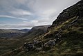
 Northern Slopes of Glenmalure Valley - geograph.org.uk - 1217218.jpg 640 × 480; 141 KB
-
 River Fraughan, Fraughan Rock Glen, Wicklow.jpg 3,258 × 4,913; 2.3 MB
-
 Road into Glenmalure, Co. Wicklow - geograph.org.uk - 1217219.jpg 640 × 480; 138 KB
-
 View across Glenmalure - geograph.org.uk - 627452.jpg 640 × 480; 69 KB
-
 Walking up Mullacor, Glenmalure, Co Wicklow 01.jpg 1,456 × 1,028; 1,017 KB
-
 Walking up Mullacor, Glenmalure, Co Wicklow 02.jpg 1,452 × 1,024; 1.11 MB
-
 Walking up Mullacor, Glenmalure, Co Wicklow 03.jpg 1,452 × 1,028; 998 KB
-

.jpg)


.jpg)
.jpg)
.jpg)

.jpg)


