Category:Grabkapelle von Wattenwyl
| Object location | | View all coordinates using: OpenStreetMap |
|---|
chapel extension to church building in Oberdiessbach in the canton of Bern, Switzerland   | |||||
| Upload media | |||||
| Instance of | |||||
|---|---|---|---|---|---|
| Part of | |||||
| Location | Oberdiessbach, Bern-Mittelland administrative district, Bernese Mittelland administrative region, Bern, Switzerland | ||||
| Street address |
| ||||
| Architectural style | |||||
| Heritage designation | |||||
 | |||||
Media in category "Grabkapelle von Wattenwyl"
The following 8 files are in this category, out of 8 total.
-
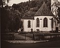 Oberdiessbach Familienkapelle-1-1 (cropped) (cropped).jpg 1,823 × 1,458; 2.54 MB
-
 Oberdiessbach Familienkapelle-1-1 (cropped).jpg 2,279 × 1,823; 3.32 MB
-
 Oberdiessbach Grabkapelle von Wattenwyl Anbau.jpg 3,136 × 2,352; 5.16 MB
-
 Oberdiessbach Grabkapelle von Wattenwyl Denkmal.jpg 2,187 × 3,295; 5.92 MB
-
 Oberdiessbach Grabkapelle von Wattenwyl Denkschrift.jpg 3,372 × 2,658; 8.18 MB
-
 Oberdiessbach Grabkapelle von Wattenwyl Wappen.jpg 3,568 × 2,676; 8.91 MB
-
 Oberdiessbach Grabkapelle von Wattenwyl.jpg 3,183 × 2,387; 5.48 MB
-
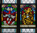 Oberdiessbach Wappenscheiben von Wattenwyl.jpg 1,642 × 1,497; 2.18 MB
_(cropped).jpg)
.jpg)


