Category:Grave of Goeden-Didier (Père-Lachaise, division 30)

Grave of Goeden-Didier (Père-Lachaise, division 30)
This building is inscrit au titre des monuments historiques de la France. It is indexed in the base Mérimée, a database of architectural heritage maintained by the French Ministry of Culture, under the reference PA00086780 .

brezhoneg  català  Deutsch  English  español  Esperanto  euskara  français  italiano  magyar  Nederlands  português do Brasil  português  română  sicilianu  slovenščina  suomi  svenska  Ελληνικά  беларуская (тарашкевіца)  македонски  русский  українська  বাংলা  +/−
Grave of Goeden-Didier  wikidata:Q112326853 reasonator:Q112326853
Title
Grave of Goeden and Didier
image of artwork listed in title parameter on this page
Object type grave
object_type QS:P31,Q173387
Genre funerary art Edit this at Wikidata
Description
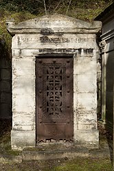
Français : Sépulture de la famille Goeden-Didier : Henriette-Marie Didier née Goeden ; Marie-Anne Goeden née Thannat ; Marie-Anne-Constance Chatelet née Goeden ; Henry Goeden ; Louis-Paul-Antoine-Juvénal Didier (1786-1837), fils de Jean-Paul Didier, sous-préfet de Grenoble sous l'Empire, préfet des Basses-Alpes aux Cent-Jours, préfet de la Somme (1830), secrétaire général du ministère de l'Intérieur (1831-1832 et 1833-1834), conseiller d'État jusqu'à sa mort ; Marie-Paul-Simon Didier ; Edme Chatelet ; Edmond-Louis-Paul-Marie Didier.
English: Tomb of Marie-Anne Thannat madame Goeden (died and/or buried 1815), Marie-Anne-Constance Goeden madame Chatelet (1789-1817), Henry Goeden (1751-1828), and Henriette-Marie Goeden madame Didier (1801-1836).
institution QS:P195,Q311
Current location
Division 30, avenue des Acacias, line 1, Salomon: U250
Tomb on the left : Faivret, on the right : Sieyès
concession number: 52809
Object location
48° 51′ 30.9″ N, 2° 23′ 44″ E Edit this at Wikidata Kartographer map based on OpenStreetMap.View all coordinates using: OpenStreetMapinfo
Inscriptions

recto in engraving:

FAMILLE GOEDENT ET DIDIER
References
Object location48° 51′ 30.87″ N, 2° 23′ 43.99″ E Kartographer map based on OpenStreetMap.View all coordinates using: OpenStreetMapinfo


<nowiki>Grave of Goeden-Didier; Goeden-Didier Mezarı; Paris'teki Père Lachaise Mezarlığı'nda kabristan; قبر في الدائرة العشرون في باريس، فرنسا</nowiki>
Grave of Goeden-Didier 
Upload media
Instance of
Genre
LocationPère-Lachaise Cemetery - Division 30, Quartier du Père-Lachaise, 20th arrondissement of Paris, Paris, Grand Paris, Île-de-France, Metropolitan France, France
Collection
Map48° 51′ 30.87″ N, 2° 23′ 43.99″ E
Authority file
Edit infobox data on Wikidata

Media in category "Grave of Goeden-Didier (Père-Lachaise, division 30)"

This category contains only the following file.