Category:Großsteingrab Westerloh I
| Object location | | View all coordinates using: OpenStreetMap |
|---|
dolmen  | |||||
| Upload media | |||||
| Instance of | |||||
|---|---|---|---|---|---|
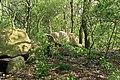
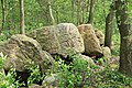
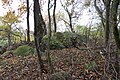
| Location | Haselünne, Emsland, Lower Saxony, Germany | ||||
 | |||||
Media in category "Großsteingrab Westerloh I"
The following 18 files are in this category, out of 18 total.
-
 Großsteingrab Westerloh 1.JPG 3,648 × 2,736; 4.16 MB
-
 Haselünne - Westerloh I 01 ies.jpg 5,616 × 3,744; 24.48 MB
-
 Haselünne - Westerloh I 02 ies.jpg 5,616 × 3,744; 26.7 MB
-
 Haselünne - Westerloh I 03 ies.jpg 5,616 × 3,744; 34.37 MB
-
 Haselünne - Westerloh I 04 ies.jpg 5,616 × 3,744; 34.98 MB
-
 Haselünne - Westerloh I 05 ies.jpg 5,616 × 3,744; 33.59 MB
-
 Haselünne - Westerloh I 06 ies.jpg 5,616 × 3,744; 33.19 MB
-
 Haselünne - Westerloh I 07 ies.jpg 5,616 × 3,744; 32.43 MB
-
 Haselünne - Westerloh I 08 ies.jpg 5,616 × 3,744; 26.1 MB
-
 Haselünne - Westerloh I 09 ies.jpg 5,616 × 3,744; 30.77 MB
-
 Haselünne - Westerloh I 10 ies.jpg 5,616 × 3,744; 27.76 MB
-
 Haselünne - Westerloh I 11 ies.jpg 5,616 × 3,744; 31.35 MB
-
 NLD Großsteingrab Westerloh 1 01.jpg 6,000 × 4,000; 4.13 MB
-
 NLD Großsteingrab Westerloh 1 02.jpg 6,000 × 4,000; 4.83 MB
-
 NLD Großsteingrab Westerloh 1 03.jpg 6,000 × 4,000; 4.6 MB
-
 NLD Großsteingrab Westerloh 1 04.jpg 6,000 × 4,000; 4.93 MB
-
 NLD Großsteingrab Westerloh 1 05.jpg 6,000 × 4,000; 4.11 MB
-
 NLD Großsteingrab Westerloh 1 06.jpg 6,000 × 4,000; 3.72 MB


