Category:HDI location maps
HDI. See: en:Human Development Index.
- (an) Mapa
- (ar) خريطة
- (ast) Mapa
- (bg) Карта
- (bn) মানচিত্র
- (bs) Karta
- (ca) Plànol
- (cs) Mapa
- (cy) Map
- (da) Kort (geografi)
- (de) Karte (Kartografie)
- (eo) Mapo
- (es) Mapa
- (et) Kaart (kartograafia)
- (fa) نقشه (زمین)
- (fi) Kartta
- (fr) Carte géographique
- (gan) 地圖
- (gl) Mapa
- (he) מפה
- (hi) मानचित्र
- (hr) Karta
- (hu) Térkép
- (id) Peta
- (is) Kort
- (it) Mappa
- (ja) 地図
- (ka) გეოგრაფიული რუკა
- (ko) 지도
- (la) Tabula geographica
- (lb) Landkaart
- (lt) Žemėlapis
- (ml) ഭൂപടം
- (ms) Peta
- (nl) Kaart (cartografie)
- (nn) Kart
- (no) Kart
- (oc) Mapa
- (pl) Mapa
- (pt) Mapa
- (ro) Hartă
- (ru) Географическая карта
- (sa) Хаарта
- (sco) Cairt
- (si) ple:Map
- (sk) Mapa
- (sl) Zemljevid
- (sq) Harta
- (sr) Карта (мапа)
- (su) Atlas
- (sv) Karta
- (sw) Ramani
- (ta) நிலப்படம்
- (tg) Харита
- (th) แผนที่
- (tl) Mapa
- (tr) Harita
- (uk) Географічна карта
- (vi) Bản đồ
- (yi) מאפע
- (zh) 地图
- (zh-classical) 地圖
- (zh-yue) 地圖
Subcategories
This category has the following 27 subcategories, out of 27 total.
- HDI maps of Africa (17 F)
- HDI maps of Asia (4 F)
- HDI maps of the world (108 F)
A
- HDI maps of Argentina (7 F)
B
- HDI maps of Bangladesh (1 F)
C
- HDI maps of China (10 F)
- HDI maps of Chile (7 F)
- HDI maps of Colombia (5 F)
E
- HDI maps of Ethiopia (1 F)
- HDI maps of Ecuador (3 F)
G
- HDI maps of Germany (3 F)
H
- HDI maps of Hungary (2 F)
I
- HDI maps of India (20 F)
M
- HDI maps of Mexico (5 F)
N
- HDI maps of Nigeria (1 F)
P
- HDI maps of Pakistan (3 F)
- HDI maps of the Philippines (3 F)
- HDI maps of Paraguay (4 F)
- HDI maps of Peru (16 F)
R
- HDI maps of Russia (7 F)
S
- HDI maps of subnational entities (63 F)
U
- HDI maps of Uzbekistan (1 F)
- HDI maps of Uruguay (4 F)
V
- HDI maps of Vietnam (3 F)
Media in category "HDI location maps"
The following 84 files are in this category, out of 84 total.
-
 2021 HDI Map of Australia.png 4,800 × 4,800; 549 KB
-
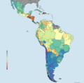
 America Latina IDH.png 6,600 × 6,502; 2.86 MB
-
 AméricaLatinaIDH.png 4,286 × 4,171; 358 KB
-
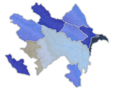 Azerbaijan regions by HDI.png 1,200 × 919; 642 KB
-
 Belize districts by HDI.png 1,027 × 893; 39 KB
-
 Bosnia regions by hdi.png 971 × 772; 65 KB
-
 BosniaandHerzegovina regions by HDI(FIXED).png 932 × 780; 65 KB
-
 Bulgarian regions by HDI.webp 919 × 580; 333 KB
-
 Countries by Human Development Index (2021).svg (1).png 343 × 414; 62 KB
-
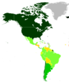
 Countries in the Americas by Human Development Index (2015).png 4,752 × 6,450; 1.86 MB
-
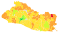
 Departamentos de El Salvador por IDH 2013.png 1,280 × 700; 145 KB
-
 Dominicanrepublic.png 1,233 × 692; 87 KB
-
 Entidades Subnacionales de America Latina por IDH.png 6,600 × 6,502; 2.85 MB
-
 Entidades Subnacionales de América Latina por IDH - Divididos en cuartiles.png 6,600 × 6,502; 1.92 MB
-
 Entidades Subnacionales de América Latina por IDH - Tramos.png 6,600 × 6,502; 2.47 MB
-
 Entidades Subnacionales de América Latina por IDH..png 6,600 × 6,502; 2.52 MB
-
 Entidades Subnacionales de Latinoamérica por IDH en tramos.png 6,600 × 6,502; 1.95 MB
-
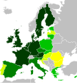 EU HDI 2017.svg 645 × 690; 532 KB
-
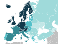 European countries by HDI (2019).svg 680 × 520; 621 KB
-
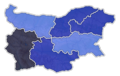
 Georgian regions by HDI 2021.png 1,136 × 722; 50 KB
-
 Greek regions by HDI.png 1,184 × 881; 103 KB
-
 GUATE IDH.jpg 720 × 661; 96 KB
-
 Guineabissau regions by HDI.png 1,181 × 746; 62 KB
-
 Haiti regions by HDI.png 960 × 701; 67 KB
-
 HDI GDPpercapitaPPP.png 671 × 487; 35 KB
-
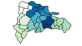
 HDI Location Costa Rica.png 820 × 709; 214 KB
-
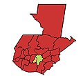
 HDI Location Guatemala.png 815 × 1,024; 368 KB
-
 Hdi Map Of Iraq.png 1,280 × 1,304; 538 KB
-
 HDI NSC method 2017 18.png 3,818 × 4,600; 947 KB
-
 Hdi of iraqi hdi.png 1,280 × 1,304; 533 KB
-
 IDH de Republica Dominicana por provincias.png 1,619 × 1,595; 213 KB
-
 IDH Guatemala Muncipal.png 594 × 643; 133 KB
-
 IDH Guatemala por departamentos 2014.png 1,143 × 1,185; 49 KB
-
 IDH Guatemala por departamentos.png 1,143 × 1,185; 49 KB
-
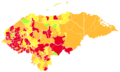
 IDH Honduras Departamental.png 635 × 397; 32 KB
-
 IDH Latinoamérica Cuartiles.png 6,600 × 6,502; 2.53 MB
-
 IDH Latinoamérica Tramos.png 6,600 × 6,502; 2.88 MB
-
 IDH Mapa El Salvador.png 1,600 × 874; 181 KB
-
 IDH MUNICIPAL GUATEMALA 2018.png 615 × 658; 134 KB
-
 IDH Municipal Honduras 2019.png 616 × 378; 92 KB
-
 IDH Municipal Honduras.png 614 × 367; 92 KB
-
 IDH por Distritos de El Salvador.png 1,265 × 705; 222 KB
-
 IDH por municipio Guatemala renovado.png 1,344 × 1,292; 290 KB
-
 IDH Provincial Panamá.png 597 × 261; 35 KB
-
 IDH Subdivisiones de América Latina por Tramos.png 6,600 × 6,600; 2.36 MB
-
 IDH-EUROPE-2009.png 332 × 203; 6 KB
-
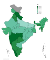 Indian states and union territories HDI (2022).png 3,818 × 4,600; 1,024 KB
-
 Ireland regions by HDI.webp 465 × 580; 127 KB
-
 Jamaica.png 1,082 × 659; 57 KB
-
 Japan HDI by Prefecture.png 1,869 × 2,485; 305 KB
-
 Kuwait regions by HDI.png 1,085 × 888; 47 KB
-
 Laos regions by HDI.png 985 × 890; 76 KB
-
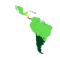
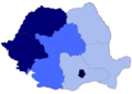
 Latin American Countries by HDI (2008).svg 629 × 810; 164 KB
-
 Latin American Countries by Human Development Index 2014.png 589 × 639; 44 KB
-
 Malaysia HDI by States 2019.svg 915 × 400; 50 KB
-
 Malaysian states and federal territories by HDI (2017).png 940 × 314; 89 KB
-
 Malaysian states and federal territories by HDI (2018).png 1,226 × 418; 89 KB
-
 Map of NUTS3 regions of the Baltic States by Human Development Index.png 3,108 × 3,110; 396 KB
-
 Mapa de Bolivia por IDH.png 1,181 × 1,181; 123 KB
-
 Mapa de Guatemala por idh.gif 770 × 969; 88 KB
-
 Mapa de Guatemala por IDH.png 579 × 597; 19 KB
-
 Mapa de las Entidades Subnacionales de America Latina por IDH.png 6,600 × 6,502; 2.47 MB
-
 Mapa de las provincias dominicanas por IDH en 2020.png 1,102 × 600; 79 KB
-
 Montenegro regions by hdi.png 980 × 898; 76 KB
-
 Myanmar regions by HDI.png 693 × 893; 72 KB
-
 Namibia regions by HDI.png 1,211 × 892; 69 KB
-
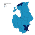
 NUTS 2 regions of Romania by HDI 2021.png 1,920 × 1,382; 221 KB
-
 Paises da América latina e Caribé por IDH.png 641 × 609; 56 KB
-
 Polish voivodeships by HDI as of 2021.png 6,000 × 4,650; 728 KB
-
 Post-Soviet states by HDI (2020).png 5,281 × 2,185; 989 KB
-
 Provincias de Rep. Dom por IDH.png 778 × 532; 82 KB
-
 Provincias de Republica Dominicana por IDH.png 1,525 × 1,503; 190 KB
-
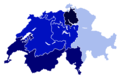 Regional HDI of Switzerland 2021.png 1,280 × 870; 139 KB
-
 Regions of New Zealand by HDI (2018).svg 532 × 568; 821 KB
-
 Regions of Romania by HDI (2017).png 800 × 576; 70 KB
-
 Saudiarabia regions by HDI.png 1,134 × 774; 69 KB
-
 Serbia regions by hdi.png 729 × 720; 52 KB
-
 Slovakia regions by HDI.png 962 × 440; 33 KB
-
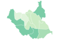
 South Sudan states by HDI.webp 799 × 580; 154 KB
-
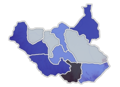
 Southsudan states by HDI.png 1,127 × 775; 49 KB
-
 Subdivisiones de América Latina - IDH por tramos.png 6,600 × 6,502; 2.88 MB
-
 UN Human Development Report 2009 America.png 544 × 652; 17 KB
-
 UN Human Development Report 2009-1- - America.png 556 × 651; 17 KB
-
 Uzbekistan regions by HDI.png 992 × 620; 45 KB


.png)

.svg_(1).png)
.png)


.svg)


.png)


.svg)


.png)


.svg)
.png)


.png)
.png)