Category:Haast-Paringa Cattle Track
historic cattle route and hiking trail in South Westland, New Zealand  | |||||
| Upload media | |||||
| Instance of | |||||
|---|---|---|---|---|---|
| Located in protected area | |||||
| Location | Westland District, West Coast Region, New Zealand | ||||
| Maintained by | |||||
| Inception |
| ||||
| Date of official opening |
| ||||
| Length |
| ||||
| Terminus | |||||
 | |||||
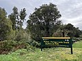
The Haast-Paringa Cattle Track was built in 1875 to take cattle from from the Landsborough and Cascade valleys north to sale yards at Whataroa, a two-week journey at best. It was used for 90 years until the Haast Pass Highway made it redundant. It is now a 33-km three-day tramp with three huts: Blue River (Blowfly), Coppermine Creek, and Māori Saddle.
Media in category "Haast-Paringa Cattle Track"
The following 18 files are in this category, out of 18 total.
-
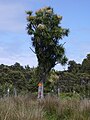 Cordyline australis at Haast-Paringa Cattle Track.jpg 1,200 × 1,600; 447 KB
-
 Cordyline australis at HPCT swing bridge.jpg 1,600 × 1,200; 265 KB
-
 Haast Paringa Cattle Track MRD 01.jpg 1,024 × 768; 470 KB
-
 Haast Paringa Cattle Track MRD 02.jpg 768 × 1,024; 505 KB
-
 Haast Paringa Cattle Track MRD 03.jpg 768 × 1,024; 625 KB
-
 Haast Paringa Cattle Track MRD 04.jpg 768 × 1,024; 648 KB
-
 Haast Paringa Cattle Track MRD 05.jpg 1,024 × 768; 591 KB
-
 Haast Paringa Cattle Track MRD 06.jpg 1,024 × 768; 443 KB
-
 Haast Paringa Cattle Track MRD 07.jpg 1,024 × 768; 616 KB
-
 Haast Paringa Cattle Track MRD 08.jpg 768 × 1,024; 486 KB
-
 Haast Paringa Cattle Track MRD 09.jpg 768 × 1,024; 439 KB
-
 HPCT waterfall.jpg 1,536 × 2,048; 451 KB
-
 Mataketake Hut DOC.jpg 1,066 × 600; 231 KB
-
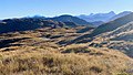 Mataketake-track-views-1920.jpg 1,066 × 600; 175 KB
-
 Mica-mine-tops-route-1920.jpg 1,066 × 600; 148 KB
-
 NLNZ Iron Hut Haast to Paringa PAColl-6208-50.jpg 1,080 × 776; 138 KB
-
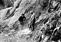 Sheet Mica Mining Westland MRD.jpg 1,080 × 749; 143 KB
-
 Through South Westland (1916) · Moreland · 179.jpg 1,534 × 2,069; 713 KB


_%C2%B7_Moreland_%C2%B7_179.jpg)