Category:Hall Caine Airport
| Object location | | View all coordinates using: OpenStreetMap |
|---|
former Commercial Airport in Ramsey, Isle of Man  | |||||
| Upload media | |||||
| Instance of | |||||
|---|---|---|---|---|---|
| Named after | |||||
| Location | Ramsey, Isle of Man, Irish Sea | ||||
| Operator | |||||
| Dissolved, abolished or demolished date |
| ||||
| Elevation above sea level |
| ||||
 | |||||
English: Hall Caine Airport is a former aerodrome in the north of the Isle of Man. Originally named Close Lake Airfield, it was used for commercial air traffic between 1935 & 1937. After this it fell into decline, although it was used again briefly in the 1990s by a local gliding club
Media in category "Hall Caine Airport"
The following 13 files are in this category, out of 13 total.
-
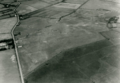 Aerial view of Hall Caine Airport, Isle of Man.png 715 × 493; 591 KB
-
 Air Mail at Hall Caine.jpg 399 × 258; 16 KB
-
 British Airways Hall Caine Schedule.png 715 × 870; 93 KB
-
 Hall Caine Airfield.jpg 960 × 720; 106 KB
-
 Hall Caine at Hall Caine!.jpg 914 × 511; 62 KB
-
 Hall Caine Timetable.png 701 × 883; 70 KB
-
 Opening of Hall Caine Airport.jpg 1,380 × 867; 221 KB
-
 Plaque commemorating Hall Caine Airport.jpg 630 × 640; 220 KB
-
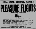 Pleasure Flights from Hall Caine Airport.png 695 × 561; 44 KB
-
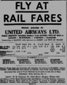
 Spartan Airways poster for Hall Caine.png 341 × 572; 47 KB
-

-

-


.jpg)
.jpg)
.jpg)