Category:Handa Island
island off the west coast of Sutherland, Scotland  | |||||
| Upload media | |||||
| Instance of |
| ||||
|---|---|---|---|---|---|
| Part of | |||||
| Location | Highland, Scottish Highlands, Scotland | ||||
| Located in or next to body of water | |||||
| Operator | |||||
| Width |
| ||||
| Length |
| ||||
| Population |
| ||||
| Area |
| ||||
| Different from | |||||
 | |||||
Main Wikipedia article: Handa Island.
Subcategories
This category has the following 6 subcategories, out of 6 total.
- Animals of Handa Island (20 F)
- Plants of Handa Island (8 F)
- Ruins on Handa Island (5 F)
G
- Great Stack of Handa (14 F)
S
- Sound of Handa (10 F)
Media in category "Handa Island"
The following 60 files are in this category, out of 60 total.
-
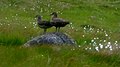 A Pair Of Great Skua - geograph.org.uk - 4026165.jpg 2,315 × 1,302; 1.48 MB
-
 A small rock awash - geograph.org.uk - 5814513.jpg 640 × 480; 113 KB
-
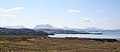 Assynt from Handa - geograph.org.uk - 820042.jpg 640 × 278; 123 KB
-
 Beach View Handa Island - geograph.org.uk - 4026156.jpg 2,560 × 1,920; 1.3 MB
-
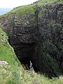 Blowhole on Handa - geograph.org.uk - 2311691.jpg 1,200 × 1,600; 910 KB
-
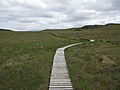 Boardwalk on Handa - geograph.org.uk - 2311797.jpg 1,600 × 1,200; 677 KB
-
 Boardwalk on Handa - geograph.org.uk - 3604891.jpg 640 × 480; 70 KB
-
 Brutschutzgebiet Handa Island.jpg 2,959 × 4,315; 3.49 MB
-
 Cliffs at Puffin Bay - geograph.org.uk - 3604895.jpg 640 × 416; 87 KB
-
 Cliffs at Puffin Bay - geograph.org.uk - 3604899.jpg 640 × 480; 107 KB
-
 Common murres on a cliff at Handa Island (Scotland).JPG 3,168 × 4,752; 8.61 MB
-
 Experimental Plots on the Machair - geograph.org.uk - 820034.jpg 640 × 427; 245 KB
-
 Felsnadel auf Handa Island.JPG 3,168 × 4,752; 7.59 MB
-
 Footpath on Handa Island - geograph.org.uk - 3604992.jpg 640 × 456; 80 KB
-
 Geo on Handa - geograph.org.uk - 2311681.jpg 1,200 × 1,600; 963 KB
-
 Geodh' a' Bhrisidh - geograph.org.uk - 3604908.jpg 479 × 640; 78 KB
-
 Geodh' Dearg - geograph.org.uk - 2311753.jpg 1,200 × 1,600; 1,009 KB
-
 Geodh' Dearg - geograph.org.uk - 3604995.jpg 640 × 469; 87 KB
-
 Geodh' na Goibhre - geograph.org.uk - 3604973.jpg 640 × 469; 77 KB
-
 Geodh' na Goibhre Cliffs - geograph.org.uk - 3604981.jpg 640 × 469; 100 KB
-
 Grassy moorland Handa Island - geograph.org.uk - 805462.jpg 640 × 480; 102 KB
-
 Handa - panoramio.jpg 4,656 × 2,646; 2.77 MB
-
 Handa graveyard - geograph.org.uk - 2311812.jpg 1,600 × 1,200; 877 KB
-
 Handa Island - geograph.org.uk - 820359.jpg 640 × 427; 250 KB
-
 Handa Island visitor centre - geograph.org.uk - 2311801.jpg 1,600 × 1,200; 552 KB
-
 Handa Island, Scotland - geograph.org.uk - 2166413.jpg 640 × 397; 57 KB
-
 Handaquinag.jpg 503 × 329; 119 KB
-
 Jetty at Tarbert - geograph.org.uk - 921510.jpg 640 × 480; 68 KB
-
 Klippen von Handa Island.JPG 4,752 × 3,168; 8.41 MB
-
 Landing on Handa Island - geograph.org.uk - 1819.jpg 570 × 424; 36 KB
-
 Landing on Handa Island - geograph.org.uk - 805563.jpg 640 × 480; 68 KB
-
 Leaving Handa Island - geograph.org.uk - 3605043.jpg 640 × 443; 75 KB
-

-
-
 Moorland Lochan on Handa - geograph.org.uk - 3604952.jpg 640 × 480; 82 KB
-
 North coast of Handa - geograph.org.uk - 3204917.jpg 1,024 × 768; 241 KB
-
 North Handa - geograph.org.uk - 820047.jpg 640 × 423; 254 KB
-
 Ordnance Survey One-Inch Sheet 9 Cape Wrath, Published 1947.jpg 10,541 × 12,892; 12.96 MB
-
 Ordnance Survey One-Inch Sheet 9 Cape Wrath, Published 1959.jpg 8,235 × 9,879; 8.24 MB
-
 Ordnance Survey Sheet NC 14 Scourie, Published 1970.jpg 10,072 × 8,818; 25.7 MB
-
 Path around Handa - geograph.org.uk - 2311784.jpg 1,600 × 1,200; 825 KB
-
 Pool on Handa - geograph.org.uk - 2311626.jpg 1,600 × 1,200; 717 KB
-
 Port an Eilein - geograph.org.uk - 3604863.jpg 640 × 451; 87 KB
-
 Port an Eilein - geograph.org.uk - 3605032.jpg 640 × 469; 85 KB
-

-
 Port an Eilein, Handa Island - geograph.org.uk - 4555924.jpg 2,592 × 1,944; 1.54 MB
-
 Puffin Breeding Site on Handa - geograph.org.uk - 3604961.jpg 640 × 480; 98 KB
-
 Remains of Handa Village - geograph.org.uk - 3604886.jpg 640 × 480; 94 KB
-
 Scourie Bay - geograph.org.uk - 771868.jpg 640 × 480; 69 KB
-
 Sea pinks and lichens south Handa - geograph.org.uk - 877654.jpg 640 × 407; 119 KB
-
 Swaabie Loch - geograph.org.uk - 3604913.jpg 640 × 480; 81 KB
-
 The northernmost tip of Handa - geograph.org.uk - 5814518.jpg 640 × 480; 79 KB
-
 Thrift covered cliff line - geograph.org.uk - 2311664.jpg 1,600 × 1,200; 815 KB
-
 Towards Geodh' Dearg - geograph.org.uk - 3605004.jpg 640 × 440; 74 KB
-
 Towards Handa Island - geograph.org.uk - 3604829.jpg 640 × 404; 54 KB
-
 Traigh na h-Airigh - geograph.org.uk - 3605013.jpg 640 × 479; 85 KB
-
 Tràigh Shourie - geograph.org.uk - 3605026.jpg 640 × 479; 82 KB
-
 View from Handa Island, Scotland - geograph.org.uk - 2166412.jpg 640 × 424; 81 KB
-
 View to Handa Island - geograph.org.uk - 773321.jpg 640 × 480; 83 KB
-
 Welcome to Handa - geograph.org.uk - 3604848.jpg 640 × 363; 49 KB


.JPG)


