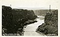
Category:Hansen Bridge (Idaho, 1919)
| Object location | | View all coordinates using: OpenStreetMap |
|---|
.jpg) | |||||
| Upload media | |||||
| Instance of | |||||
|---|---|---|---|---|---|
| Location | Jerome County, Idaho | ||||
| Crosses | |||||
| Carries | |||||
| Dissolved, abolished or demolished date |
| ||||
| Structure replaced by | |||||
 | |||||
Media in category "Hansen Bridge (Idaho, 1919)"
The following 2 files are in this category, out of 2 total.
-
 -IDAHO-B-0026- Snake River - Hansen Bridge (5566629112).jpg 1,613 × 1,012; 282 KB
-
 Hansen Bridge interpretive sign, Jun 17.jpg 2,592 × 1,944; 2.38 MB
