Category:Harty
English: Harty is a small hamlet on the Isle of Sheppey in Kent consisting of a few cottages, a church and a public house, the Ferry Inn (a Grade II listed building). At the 2011 Census the population of the hamlet was included in the civil parish of Leysdown (→Harty)
Français : Harty est un petit hameau de l' Île de Sheppey dans le Kent, et est constitué de quelques cottages, une église et un bâtiment public, The Ferry Inn. L'église est dépourvue d'électricité et d'eau courante et date du . (→Harty (Kent))

hamlet and former civil parish in Kent, England, UK  | |||||
| Upload media | |||||
| Instance of |
| ||||
|---|---|---|---|---|---|
| Location | Leysdown, Swale, Kent, South East England, England | ||||
| Different from | |||||
 | |||||
Subcategories
This category has the following 2 subcategories, out of 2 total.
F
- Ferry Inn, Harty (5 F)
T
Media in category "Harty"
The following 58 files are in this category, out of 58 total.
-

-
 Avenue of Trees on Isle of Harty - geograph.org.uk - 1023402.jpg 640 × 481; 125 KB
-

-
 Bridleway to Ferry Inn - geograph.org.uk - 1312050.jpg 640 × 480; 117 KB
-
 Construction of House - geograph.org.uk - 1023406.jpg 640 × 481; 94 KB
-
 Conversion of Mockets Farm Barn - geograph.org.uk - 1312058.jpg 640 × 480; 50 KB
-
 Derelict cottage, Harty - geograph.org.uk - 1407259.jpg 640 × 480; 70 KB
-
 Disused School at Harty - geograph.org.uk - 1286917.jpg 640 × 480; 77 KB
-
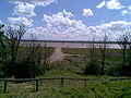
 Ditch and Earthbank Seawall - geograph.org.uk - 1023515.jpg 640 × 481; 69 KB
-
 Ditch and Seawall, Harty Marshes - geograph.org.uk - 1023522.jpg 640 × 481; 88 KB
-

-
 DIY Footbridge over ditch to Seawall - geograph.org.uk - 1023529.jpg 640 × 481; 117 KB
-
 Flooded bridleway in Leysdown, Kent - geograph.org.uk - 389537.jpg 640 × 426; 99 KB
-
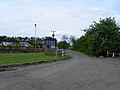 Harty Ferry Road - geograph.org.uk - 1286809.jpg 640 × 480; 65 KB
-
 Harty Ferry Road - geograph.org.uk - 1312048.jpg 640 × 480; 87 KB
-
 Harty Ferry, looking towards Oare terminus.jpg 1,152 × 864; 151 KB
-

-
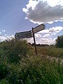 Harty signpost.jpg 864 × 1,152; 140 KB
-
 Harty, a barn in semi-silhouette - geograph.org.uk - 1333334.jpg 640 × 480; 68 KB
-
 Harty, a boat on The Swale - geograph.org.uk - 1333325.jpg 640 × 480; 55 KB
-
 Harty, Capel Fleet - geograph.org.uk - 1333393.jpg 640 × 480; 67 KB
-
 Harty, field over fence - geograph.org.uk - 1333385.jpg 640 × 480; 85 KB
-
 Harty, heading for the shore - geograph.org.uk - 1333283.jpg 640 × 480; 98 KB
-
 Harty, Isle of Sheppey - geograph.org.uk - 1407271.jpg 640 × 480; 79 KB
-

-
 Harty, redundant Victorian postbox - geograph.org.uk - 1333345.jpg 480 × 640; 128 KB
-
 Harty, the small jetty - geograph.org.uk - 1333291.jpg 640 × 480; 70 KB
-
 Harty, view along The Swale - geograph.org.uk - 1333299.jpg 640 × 480; 65 KB
-
 Harty, view from the pub beer garden - geograph.org.uk - 1333330.jpg 640 × 480; 89 KB
-

-
 Old Counter Wall, ditch and bank - geograph.org.uk - 1023270.jpg 640 × 481; 96 KB
-

-
 Park Farm, Harty - geograph.org.uk - 4575018.jpg 2,272 × 1,704; 758 KB
-
 Park Farmhouse - geograph.org.uk - 4436363.jpg 640 × 426; 55 KB
-
 Park Farmhouse - geograph.org.uk - 4436467.jpg 640 × 426; 36 KB
-
 Saltworks in Harty Marshes - geograph.org.uk - 1023372.jpg 640 × 481; 78 KB
-

-
 Sayers Court Cottages, Harty - geograph.org.uk - 1286938.jpg 640 × 480; 61 KB
-
 Sayes Court Farm, Harty - geograph.org.uk - 4575044.jpg 2,272 × 1,704; 912 KB
-
 Sayes Court Farmhouse - geograph.org.uk - 4431081.jpg 640 × 426; 63 KB
-
 Sayes Court Farmhouse - geograph.org.uk - 4431094.jpg 640 × 426; 72 KB
-
 Sayes Court, Harty - geograph.org.uk - 1407266.jpg 640 × 480; 69 KB
-

-
 Sign on Footpath, near Mocketts Farm - geograph.org.uk - 1023499.jpg 640 × 481; 102 KB
-
 Slipway into the Swale Strait - geograph.org.uk - 1312053.jpg 640 × 480; 93 KB
-

-
 Unclassified Road, Harty - geograph.org.uk - 1286964.jpg 640 × 480; 65 KB
-
 View from end of Harty Ferry Road - geograph.org.uk - 1286796.jpg 640 × 480; 63 KB
-
 View toward Horse Sands - geograph.org.uk - 1286893.jpg 640 × 480; 75 KB
-
 Wheat Field in Harty, Sheppey.jpg 4,592 × 3,448; 19.42 MB
-
 Cereal crop on Harty Marsh - geograph.org.uk - 359554.jpg 640 × 481; 107 KB
-
 Game Pens at Elliot's Farm - geograph.org.uk - 46632.jpg 640 × 482; 60 KB
-
 Harty Ferry Road - geograph.org.uk - 360884.jpg 640 × 480; 80 KB
-
 Harty Ferry Road, Isle of Sheppey - geograph.org.uk - 1407256.jpg 640 × 480; 71 KB
-
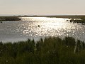
 Harty Marsh - geograph.org.uk - 360818.jpg 640 × 480; 78 KB
-
 Harty Marshes - geograph.org.uk - 389737.jpg 640 × 426; 108 KB
-
 Pump outflow at Pump Hill - geograph.org.uk - 360894.jpg 640 × 480; 136 KB
-
 Shooters Hide on Path to Muswell Manor - geograph.org.uk - 46634.jpg 640 × 482; 67 KB


