Category:Hauptstrasse 70 (Zihlschlacht)
| Object location | | View all coordinates using: OpenStreetMap |
|---|
|
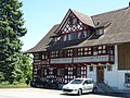
This is a category about a cultural property of regional significance in Switzerland with KGS number 13876
|
 | |||||
| Upload media | |||||
| Instance of | |||||
|---|---|---|---|---|---|
| Part of | |||||
| Location |
| ||||
| Street address |
| ||||
| Heritage designation |
| ||||
 | |||||
Media in category "Hauptstrasse 70 (Zihlschlacht)"
The following 4 files are in this category, out of 4 total.
-
 Hauptstrasse 70 in Zihlschlacht TG.jpg 3,840 × 3,360; 8.59 MB
-
 Hauptstrasse 70 Zihlschlacht.jpg 2,560 × 1,920; 2.92 MB
-
 Zihlschlacht Hauptstr 70.jpg 2,560 × 1,920; 1.52 MB
-
 Zihlschlacht Hauptstrasse 70.jpg 2,560 × 1,920; 1.63 MB


