Category:Haus Werthplatz 12 (Eupen)
| Object location | | View all coordinates using: OpenStreetMap |
|---|
building in Eupen, Belgium .jpg) | |||||
| Upload media | |||||
| Instance of | |||||
|---|---|---|---|---|---|
| Location | Eupen, Arrondissement of Verviers, Province of Liege, Walloon Region, Belgium | ||||
| Street address |
| ||||
| Heritage designation |
| ||||
 | |||||
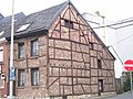
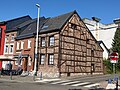
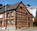
Deutsch: Das Fachwerkhaus wurde Ende des 17. Jahrhunderts als Unterkunft eines Webers gebaut. Vermutlich hat es jedoch einen Kern aus dem 15. Jahrhundert, wie die Giebelwand aus Fachwerk andeutet. (Quelle: ostbelgienkulturerebe.be)
Français : La maison à colombage a été construite à la fin du XVIIe siècle pour accueillir un tisserand. Vraisemblablement, elle a un noyau du 15ème siècle, comme le suggère le mur à pignon de la construction en bois. (Source : ostbelgienkulturerebe.be)
Nederlands: Het vakwerkhuis werd aan het einde van de 17e eeuw gebouwd als accommodatie voor een wever. Vermoedelijk heeft het echter een kern uit de 15e eeuw, zoals de puntgevel van de houten constructie suggereert. (Bron: ostbelgienkulturerebe.be)
English: The half-timbered house was built at the end of the 17th century as the accommodation of a weaver. Presumably, it has a core from the 15th century, as the gabled wall of timbered construction suggests. (Source: ostbelgienkulturerebe.be)
|
This is a category about a monument of the German-speaking Community of Belgium, number: 31359
|
Media in category "Haus Werthplatz 12 (Eupen)"
The following 6 files are in this category, out of 6 total.
-
 EUPEN Werthplatz 12 (1).JPG 2,048 × 1,536; 987 KB
-
 Haus Werthplatz 12 (1).jpg 4,032 × 3,024; 4.15 MB
-
 Haus Werthplatz 12 (2).jpg 4,032 × 3,024; 5.01 MB
-
 Haus Werthplatz 12 (3).jpg 3,024 × 4,032; 4.74 MB
-
 Haus Werthplatz 12 (4).jpg 3,024 × 4,032; 4.15 MB
-
 Werthplatz 12, Eupen.JPG 4,115 × 3,452; 3.08 MB
.JPG)
.jpg)
.jpg)
.jpg)
