Category:Havenstreet and Ashey
civil parish on the Isle of Wight, in the United Kingdom | |||||
| Upload media | |||||
| Instance of | |||||
|---|---|---|---|---|---|
| Named after | |||||
| Location | Isle of Wight, South East England, England | ||||
 | |||||
Subcategories
This category has the following 6 subcategories, out of 6 total.
Media in category "Havenstreet and Ashey"
The following 190 files are in this category, out of 190 total.
-
 A bridleway off Ashey Road - geograph.org.uk - 2652542.jpg 800 × 600; 351 KB
-
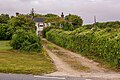
 A footpath off Rowlands Lane - geograph.org.uk - 2653443.jpg 800 × 600; 219 KB
-
 A glimpse of W8 'Freshwater' at Haven Street - geograph.org.uk - 6348771.jpg 1,024 × 768; 297 KB
-
 A quarry on Mersley Down - geograph.org.uk - 2653427.jpg 800 × 600; 257 KB
-
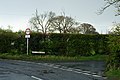
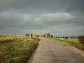
 A road junction on Arreton Down - geograph.org.uk - 2653421.jpg 800 × 600; 174 KB
-
 A Winter's morning - geograph.org.uk - 985283.jpg 640 × 480; 60 KB
-
 Alverstone, Ashey Down - geograph.org.uk - 6302492.jpg 5,847 × 3,898; 4.62 MB
-
 Alverstone, Ashey Down - geograph.org.uk - 6302495.jpg 6,906 × 4,604; 6.7 MB
-
 Arreton Down - geograph.org.uk - 3335090.jpg 2,592 × 1,944; 1.86 MB
-
 Ashey Down - geograph.org.uk - 5693776.jpg 1,000 × 665; 897 KB
-
 Ashey from the cemetery - geograph.org.uk - 6335282.jpg 1,024 × 768; 231 KB
-
 Ashey Road and woods at East Ashey Farm - geograph.org.uk - 3024536.jpg 1,000 × 750; 468 KB
-
 Ashey Road bridge over IOW Steam Railway - geograph.org.uk - 3024559.jpg 1,000 × 750; 697 KB
-
 Ashey Road Garage selling Regent petrol - geograph.org.uk - 3024553.jpg 1,000 × 750; 494 KB
-
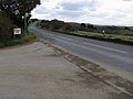
 Ashey Road near Greenlane Farm - geograph.org.uk - 2652522.jpg 800 × 600; 320 KB
-
 Ashey Seamark - geograph.org.uk - 5692662.jpg 665 × 1,000; 652 KB
-
 Ashey Seamark - geograph.org.uk - 5692663.jpg 1,000 × 665; 533 KB
-
 Barn at Great Upton, Isle of Wight - geograph.org.uk - 2898960.jpg 3,673 × 2,444; 7.62 MB
-
 Bedford type O lorry on display - geograph.org.uk - 6348055.jpg 1,024 × 768; 341 KB
-
 Blackthorn by the railway - geograph.org.uk - 6370602.jpg 1,024 × 768; 364 KB
-
 Booking office, Haven Street station - geograph.org.uk - 6348363.jpg 1,024 × 768; 435 KB
-
 Briddlesford Lodge Farm - geograph.org.uk - 5678329.jpg 1,000 × 665; 806 KB
-
 Briddlesford Road - geograph.org.uk - 1045195.jpg 640 × 480; 77 KB
-

-
 Building at Haven Street station - geograph.org.uk - 6348356.jpg 1,024 × 768; 270 KB
-
 Busy platform, Haven Street station - geograph.org.uk - 6348928.jpg 1,024 × 768; 260 KB
-
 Cattle by the railway - geograph.org.uk - 5352376.jpg 640 × 480; 172 KB
-
 Combley Farm - geograph.org.uk - 5681889.jpg 1,000 × 665; 739 KB
-
 Combley Great Wood - geograph.org.uk - 1045219.jpg 640 × 480; 128 KB
-
 Combley Great Wood, Isle of Wight - geograph.org.uk - 5496257.jpg 3,000 × 4,000; 4.51 MB
-
 Coppid Hall Farm - geograph.org.uk - 5693778.jpg 1,000 × 665; 648 KB
-
 Coppid Hall Farm - geograph.org.uk - 5693779.jpg 1,000 × 665; 832 KB
-
 Coppidhall Farm - geograph.org.uk - 1045257.jpg 640 × 480; 59 KB
-
 Crossroads mini-roundabout south of Ryde - geograph.org.uk - 4779198.jpg 800 × 581; 124 KB
-

-

-
 D2059 heading for yard, Haven Street - geograph.org.uk - 6348032.jpg 1,024 × 768; 388 KB
-
 Deacons Lane bridge over IOW steam railway - geograph.org.uk - 3026210.jpg 750 × 1,000; 677 KB
-
 Derelict buildings, Ashey - geograph.org.uk - 6370588.jpg 1,024 × 768; 271 KB
-
 Diesel shunter Army 235 at Haven Street - geograph.org.uk - 6348759.jpg 1,024 × 768; 305 KB
-
 Distant signal, Isle of Wight Steam Railway - geograph.org.uk - 6347764.jpg 1,024 × 768; 468 KB
-
 Dores Hill Cottage - geograph.org.uk - 5686341.jpg 1,000 × 665; 923 KB
-
 Down end of Haven Street station - geograph.org.uk - 6347841.jpg 1,024 × 768; 305 KB
-
 Down train approaching Haven Street station - geograph.org.uk - 6348879.jpg 1,024 × 768; 360 KB
-
 Drive to West Ashey Farm - geograph.org.uk - 1045322.jpg 640 × 480; 70 KB
-
 East Ashey Lane, Isle of Wight - geograph.org.uk - 2899235.jpg 3,673 × 2,444; 7.7 MB
-
 Entrance to Duxmore Farm - geograph.org.uk - 1045175.jpg 640 × 480; 64 KB
-
 Entrance to fishing lakes - geograph.org.uk - 5682787.jpg 1,000 × 665; 1.13 MB
-
 Fairfields Farm on Stroud Wood Road - geograph.org.uk - 2653460.jpg 800 × 600; 318 KB
-
 Falconry show, Havenstreet - geograph.org.uk - 6348279.jpg 1,024 × 684; 269 KB
-
 Farm buildings at Rowlands Farm - geograph.org.uk - 2653446.jpg 800 × 600; 215 KB
-
 Field by Guildfordheath Copse - geograph.org.uk - 5686224.jpg 1,000 × 665; 875 KB
-
 Field near Knight's Farm - geograph.org.uk - 5686342.jpg 1,000 × 665; 786 KB
-
 Fields adjacent to Robin Hill Country Park, Isle of Wight - geograph.org.uk - 5496276.jpg 3,055 × 1,923; 1.36 MB
-
 Fields north of railway - geograph.org.uk - 5352429.jpg 640 × 480; 118 KB
-
 Firestone Copse car park - geograph.org.uk - 4731052.jpg 1,600 × 1,200; 1.04 MB
-
 Firestone Copse, Wootton Bridge, Isle of Wight - geograph.org.uk - 3561837.jpg 4,000 × 2,666; 7.42 MB
-
 Gated track towards woodland - geograph.org.uk - 6347686.jpg 1,024 × 768; 367 KB
-
 Gatehouse Road, Ashey, Isle of Wight - geograph.org.uk - 2898944.jpg 3,030 × 2,016; 7.61 MB
-
 Gatehouse Road, Great Upton, Isle of Wight - geograph.org.uk - 2898953.jpg 4,592 × 3,056; 7.43 MB
-
 Great Briddlesford Farm - geograph.org.uk - 5686325.jpg 1,000 × 665; 574 KB
-
 Great Briddlesford Farm - geograph.org.uk - 5686332.jpg 1,000 × 665; 816 KB
-
 Great Upton, Isle of Wight - geograph.org.uk - 5497463.jpg 3,990 × 2,992; 3.16 MB
-
 Green Lane towards Greenlane farm - geograph.org.uk - 2652528.jpg 800 × 600; 285 KB
-
 Gutter Repairs Required - geograph.org.uk - 2899194.jpg 2,662 × 4,000; 7.69 MB
-
 Hare and Hounds - geograph.org.uk - 5678344.jpg 1,000 × 665; 951 KB
-
 Hare and Hounds - geograph.org.uk - 5678346.jpg 1,000 × 665; 796 KB
-
 Haven Street railway station, Isle of Wight - geograph.org.uk - 5145346.jpg 1,600 × 1,200; 395 KB
-

-
 Haven Street up advance starter signal - geograph.org.uk - 6349217.jpg 1,024 × 768; 480 KB
-
 Haven Street up inner home signal - geograph.org.uk - 6347832.jpg 1,024 × 768; 425 KB
-
 Havenstreet Main Road - geograph.org.uk - 6349115.jpg 1,024 × 768; 479 KB
-
 Havenstreet Station - geograph.org.uk - 5603039.jpg 424 × 640; 61 KB
-
 Havenstreet Station - geograph.org.uk - 5834898.jpg 640 × 480; 107 KB
-
 Havenstreet Station - geograph.org.uk - 5894960.jpg 1,600 × 1,200; 590 KB
-
 Havenstreet Station - geograph.org.uk - 5894976.jpg 1,600 × 1,200; 407 KB
-
 Havenstreet Station - geograph.org.uk - 5894996.jpg 1,600 × 1,200; 394 KB
-
 Havenstreet station on the Isle of Wight Steam Railway - geograph.org.uk - 5809423.jpg 2,592 × 1,944; 1.28 MB
-
 Havenstreet, Inside the White Lion - geograph.org.uk - 5171160.jpg 640 × 480; 85 KB
-
 Havenstreet, White Lion pub on left - geograph.org.uk - 5171158.jpg 1,024 × 768; 163 KB
-
 Inside carriage and wagon shop, Haven Street - geograph.org.uk - 6348696.jpg 1,024 × 768; 293 KB
-

-
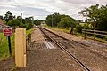
 Isle of Wight Steam Railway - Ashey station - geograph.org.uk - 6370575.jpg 1,024 × 768; 480 KB
-
 Isle of Wight Steam Railway - geograph.org.uk - 5691575.jpg 1,000 × 665; 652 KB
-
 Isle of Wight Steam Railway - geograph.org.uk - 6370221.jpg 1,024 × 768; 490 KB
-
 Isle of Wight Steam Railway - geograph.org.uk - 6370552.jpg 1,024 × 768; 388 KB
-

-

-
 Junction with Green Lane near Greenlane Farm - geograph.org.uk - 3024543.jpg 1,000 × 750; 573 KB
-
 Knight's Cross - geograph.org.uk - 5686344.jpg 665 × 1,000; 680 KB
-
 Knight's Cross - geograph.org.uk - 5686345.jpg 1,000 × 665; 733 KB
-
 Knight's Cross Lane - geograph.org.uk - 5918542.jpg 3,976 × 2,982; 2.43 MB
-
 Large field in Great Wood - geograph.org.uk - 4704844.jpg 800 × 600; 92 KB
-
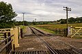
 Level crossing, Isle of Wight Steam Railway - geograph.org.uk - 6347774.jpg 1,024 × 768; 484 KB
-
 Level crossing, Isle of Wight Steam Railway - geograph.org.uk - 6369975.jpg 1,024 × 768; 294 KB
-
 Lineside, Isle of Wight Steam Railway - geograph.org.uk - 5352389.jpg 640 × 480; 197 KB
-
 Lineside, Isle of Wight Steam Railway - geograph.org.uk - 5352393.jpg 640 × 480; 112 KB
-
 Lineside, Isle of Wight Steam Railway - geograph.org.uk - 6347671.jpg 1,024 × 768; 410 KB
-
 Little Duxmore Farm House - geograph.org.uk - 5714458.jpg 3,944 × 2,784; 2.32 MB
-
 Little Lynn Common - geograph.org.uk - 3561885.jpg 4,000 × 2,666; 7.51 MB
-
 Little Whitefield - geograph.org.uk - 6369957.jpg 1,024 × 684; 238 KB
-
 Littletown Lane - geograph.org.uk - 5678340.jpg 1,000 × 665; 879 KB
-

-

-
 Lorry trailers - geograph.org.uk - 5681883.jpg 800 × 532; 150 KB
-
 Manitou bucket loader, Haven Street yard - geograph.org.uk - 6348561.jpg 1,024 × 768; 212 KB
-
 Museum at Havenstreet station - geograph.org.uk - 5894926.jpg 1,600 × 1,200; 640 KB
-
 Near Combley Farm - geograph.org.uk - 5681891.jpg 1,000 × 665; 822 KB
-
 Near Wootton, Isle of Wight - geograph.org.uk - 2491057.jpg 3,504 × 2,336; 519 KB
-
 Northbrooke House - geograph.org.uk - 5694491.jpg 1,000 × 665; 751 KB
-
 Oakfield Cottage - geograph.org.uk - 5692204.jpg 1,000 × 665; 1.02 MB
-
 Oakfield Farm - geograph.org.uk - 5692200.jpg 1,000 × 665; 892 KB
-

-
 Packsfield Lane level crossing - geograph.org.uk - 5691571.jpg 1,000 × 665; 941 KB
-
 Packsfield Lane level crossing - geograph.org.uk - 5691573.jpg 1,000 × 665; 828 KB
-
 Passing The Token - geograph.org.uk - 5602902.jpg 640 × 424; 85 KB
-
 Path in Combley Great Wood, Isle of Wight - geograph.org.uk - 5496251.jpg 3,000 × 4,000; 4.08 MB
-
 Path in Firestone Copse - geograph.org.uk - 4816532.jpg 1,600 × 1,200; 1.19 MB
-
 Path in Firestone Copse - geograph.org.uk - 4816544.jpg 1,600 × 1,200; 1.25 MB
-
 Picnic area, Firestone Copse, IOW - geograph.org.uk - 3320684.jpg 1,183 × 1,600; 559 KB
-
 Pitt Cottages - geograph.org.uk - 5679414.jpg 1,000 × 665; 938 KB
-
 Plaque, Ashey Seamark - geograph.org.uk - 5692664.jpg 1,000 × 665; 579 KB
-
 Post box by the bus stop - geograph.org.uk - 3860653.jpg 480 × 640; 76 KB
-
 Public footpath R13 at Little Duxmore - geograph.org.uk - 5714436.jpg 3,650 × 2,831; 2.76 MB
-
 Public footpath R13 towards Little Duxmore, Isle of Wight - geograph.org.uk - 5500043.jpg 3,891 × 2,731; 2.68 MB
-

-
 Public footpath R4 towards Quarr, Isle of Wight - geograph.org.uk - 5497476.jpg 3,776 × 2,774; 2.28 MB
-
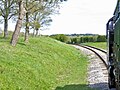
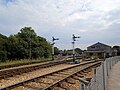
 Railway approaching Ashey station - geograph.org.uk - 5352469.jpg 640 × 480; 189 KB
-

-
 Railway through Rowlands Wood - geograph.org.uk - 5352418.jpg 640 × 480; 224 KB
-
 Refreshment room, Haven Street station - geograph.org.uk - 6349112.jpg 1,024 × 768; 307 KB
-

-
 Road to Greenlane Farm - geograph.org.uk - 4548097.jpg 4,896 × 3,672; 6.66 MB
-
 Rowlands Cross near Havenstreet - geograph.org.uk - 6335259.jpg 1,024 × 768; 245 KB
-
 Rowlands Lane taken from the rail bridge - geograph.org.uk - 2653447.jpg 800 × 600; 334 KB
-
 Rowlands Lane, Mersley Down - geograph.org.uk - 2653435.jpg 800 × 600; 223 KB
-
 Shiloh - geograph.org.uk - 5691570.jpg 1,000 × 665; 883 KB
-
 Siding towards car park, Haven Street station - geograph.org.uk - 6348807.jpg 1,024 × 768; 376 KB
-
 Siding, Haven Street station - geograph.org.uk - 6348373.jpg 1,024 × 768; 248 KB
-
 Signal at Havenstreet - geograph.org.uk - 5895006.jpg 1,600 × 1,200; 546 KB
-
 Signal, Isle of Wight Steam Railway - geograph.org.uk - 6347782.jpg 1,024 × 768; 499 KB
-
 Signals at Havenstreet station - geograph.org.uk - 5895012.jpg 1,600 × 1,200; 476 KB
-
 Silage bales - geograph.org.uk - 5681872.jpg 1,000 × 665; 946 KB
-
 Speeds Lane - geograph.org.uk - 1045241.jpg 640 × 480; 77 KB
-
 Sprucing Up A Signal - geograph.org.uk - 5602912.jpg 424 × 640; 54 KB
-
 Staggered crossroads near East Ashey Farm - geograph.org.uk - 3024541.jpg 1,000 × 750; 521 KB
-

-
 Stile - geograph.org.uk - 5686227.jpg 1,000 × 665; 1.09 MB
-
 Stroud Farm on Stroud Wood Road - geograph.org.uk - 2653464.jpg 800 × 600; 267 KB
-
 Stroud Wood Road - geograph.org.uk - 1045273.jpg 640 × 480; 81 KB
-
 Stroud Wood Road - geograph.org.uk - 2653465.jpg 800 × 600; 239 KB
-
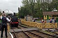
 Taking on Water - geograph.org.uk - 2851172.jpg 3,903 × 2,597; 7.73 MB
-
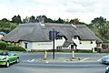
 Thatched cottage, Downend, IOW - geograph.org.uk - 3311797.jpg 1,600 × 764; 221 KB
-
 The Hare and Hounds, Downend - geograph.org.uk - 5149328.jpg 640 × 428; 139 KB
-
 The Hare ^ Hounds on Downend Road - geograph.org.uk - 2653415.jpg 800 × 600; 218 KB
-
 The Hare ^ Hounds, Downend - geograph.org.uk - 3323150.jpg 640 × 480; 46 KB
-
 The Island Line - geograph.org.uk - 1045306.jpg 640 × 480; 113 KB
-
 Third Class at Havenstreet - geograph.org.uk - 5602887.jpg 424 × 640; 56 KB
-
 Top of Mill Pond - geograph.org.uk - 4816538.jpg 1,600 × 1,200; 874 KB
-
 Towards Greenhills - geograph.org.uk - 5686230.jpg 1,000 × 665; 803 KB
-
 Towards the Hare and Hounds - geograph.org.uk - 5681880.jpg 800 × 532; 142 KB
-
 Track through Guildfordheath Copse - geograph.org.uk - 5686194.jpg 1,000 × 665; 1.05 MB
-
 Track to Combley Farm - geograph.org.uk - 5681367.jpg 800 × 532; 118 KB
-
 Track to Combley Farm - geograph.org.uk - 5681369.jpg 1,000 × 665; 721 KB
-
 Track to Great Briddlesford Farm - geograph.org.uk - 5686335.jpg 1,000 × 665; 854 KB
-
 Track to Great Briddlesford Farm - geograph.org.uk - 5686337.jpg 1,000 × 665; 850 KB
-
 Track to Great Briddlesford Farm - geograph.org.uk - 5686339.jpg 1,000 × 665; 939 KB
-
 Train approaching Deacons Lane bridge - geograph.org.uk - 5352493.jpg 640 × 480; 145 KB
-
 Train Story at Havenstreet - geograph.org.uk - 5602895.jpg 640 × 424; 79 KB
-
 Train Story, Havenstreet - geograph.org.uk - 6348785.jpg 1,024 × 768; 300 KB
-
 Train Story, IWSR - geograph.org.uk - 5174477.jpg 1,024 × 768; 151 KB
-
 Underpass under railway - geograph.org.uk - 6347606.jpg 1,024 × 768; 446 KB
-
 Van body used as platelayer's cabin, Havenstreet - geograph.org.uk - 6349119.jpg 1,024 × 768; 431 KB
-
 Victorian train in the 'Train Story' - geograph.org.uk - 4352609.jpg 1,600 × 1,064; 314 KB
-

-

-

-

-

-
 View From Ashley Down - geograph.org.uk - 4211080.jpg 4,000 × 2,666; 7.35 MB
-
 View from train east of Ashey - geograph.org.uk - 5352483.jpg 640 × 480; 131 KB
-
 W11 over the wheel drop, Haven Street yard - geograph.org.uk - 6348556.jpg 1,024 × 768; 243 KB
-
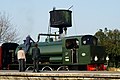
 W8 'Freshwater' at Haven Street - geograph.org.uk - 6349013.jpg 1,024 × 768; 389 KB
-
 West Ashey Cottages - geograph.org.uk - 5693765.jpg 1,000 × 665; 744 KB
-
 West Ashey Cottages - geograph.org.uk - 5693766.jpg 1,000 × 665; 686 KB
-
 West Ashey Farm - geograph.org.uk - 835617.jpg 640 × 480; 146 KB
-
 Whistle board, Isle of Wight Steam Railway - geograph.org.uk - 6369978.jpg 1,024 × 768; 450 KB
-
 White Hart - geograph.org.uk - 5693780.jpg 1,000 × 665; 815 KB
-
 Yard at Haven Street - geograph.org.uk - 6348795.jpg 1,024 × 768; 315 KB
-
 Meadow on Combley to Duxmore bridleway - geograph.org.uk - 473360.jpg 640 × 477; 113 KB


