Category:Herrgottsruhkapelle (Oberndorf am Lech)
This is the category of the Bavarian Baudenkmal (cultural heritage monument) with the ID D-7-79-196-2 (Wikidata)
|
| Object location | | View all coordinates using: OpenStreetMap |
|---|
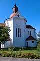
building in Oberndorf am Lech, Swabia, Germany  | |||||
| Upload media | |||||
| Instance of | |||||
|---|---|---|---|---|---|
| Location | Oberndorf am Lech, Donau-Ries, Swabia, Bavaria, Germany | ||||
| Street address |
| ||||
| Heritage designation | |||||
 | |||||
Media in category "Herrgottsruhkapelle (Oberndorf am Lech)"
The following 6 files are in this category, out of 6 total.
-
 Kapelle Oberndorf.jpg 1,728 × 2,304; 1.51 MB
-
 Kirche Oberndorf.jpg 1,536 × 2,304; 830 KB
-
 Oberndorf Herrgottsruh 410.JPG 2,336 × 3,590; 7.08 MB
-
 Oberndorf Herrgottsruh 412.JPG 3,758 × 2,512; 7.61 MB
-
 Oberndorf Herrgottsruh 413.JPG 2,471 × 3,684; 5.9 MB
-
 Oberndorf Herrgottsruh Christus 411.JPG 3,230 × 2,153; 4.05 MB


