Category:Herrnhut, Zisterne Dürningerstraße
| Upload media | |||||
| Instance of | |||||
|---|---|---|---|---|---|
| Location | Saxony, Germany | ||||
| Heritage designation | |||||
 | |||||

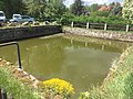
Deutsch: Zisterne in Herrnhut, Dürningerstraße, 18. Jahrhundert; Zeugnis der Trinkwasserversorgung des Ortes, ortsgeschichtlich von Bedeutung
English: Cistern in Herrhut, Dürningerstraße, 18th century; testimony of the drinking water supply of the place, of historical significance
| Object location | | View all coordinates using: OpenStreetMap |
|---|
| (Wikidata) |
Media in category "Herrnhut, Zisterne Dürningerstraße"
The following 9 files are in this category, out of 9 total.
-
 Herrnhut, Zisterne Dürningerstraße 01.jpg 4,032 × 1,816; 2.62 MB
-
 Herrnhut, Zisterne Dürningerstraße 02.jpg 4,032 × 1,816; 2.08 MB
-
 Herrnhut, Zisterne Dürningerstraße (1).jpg 4,032 × 3,024; 3.82 MB
-
 Herrnhut, Zisterne Dürningerstraße (2).jpg 4,032 × 3,024; 4.13 MB
-
 Herrnhut, Zisterne Dürningerstraße (3).jpg 4,032 × 3,024; 3.9 MB
-
 Herrnhut, Zisterne Dürningerstraße (4).jpg 4,032 × 3,024; 4.32 MB
-
 Herrnhut, Zisterne Dürningerstraße (5).jpg 4,032 × 3,024; 4.27 MB
-
 Herrnhut, Zisterne Dürningerstraße (6).jpg 6,718 × 3,958; 8.57 MB
-
 Herrnhut, Zisterne Dürningerstraße (7).jpg 4,032 × 3,024; 4.1 MB


.jpg)
.jpg)
.jpg)
.jpg)
.jpg)
.jpg)
.jpg)