Category:Hervormde kerk (Blankenham)
| Object location | | View all coordinates using: OpenStreetMap |
|---|
| Upload media | |||||
| Instance of | |||||
|---|---|---|---|---|---|
| Location | Blankenham, Overijssel, Netherlands | ||||
| Street address |
| ||||
| Located on street |
| ||||
| Heritage designation |
| ||||
 | |||||
Nederlands: Protestantsekerk, Blankenham - anno 1893
|
This is a category about rijksmonument number 387546
|
| Address |
|
Media in category "Hervormde kerk (Blankenham)"
The following 15 files are in this category, out of 15 total.
-
 Blankenham-NH-Kerk-2011.JPG 3,888 × 2,592; 5.55 MB
-
 Exterieur NOORDGEVEL - Blankenham - 20277085 - RCE.jpg 1,200 × 954; 231 KB
-
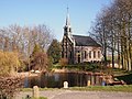
 Exterieur OVERZICHT, WESTGEVEL, ZUIDGEVEL - Blankenham - 20277084 - RCE.jpg 960 × 1,200; 260 KB
-
 Exterieur ZUIDGEVEL, TOEGANG - Blankenham - 20277087 - RCE.jpg 958 × 1,200; 318 KB
-
 Exterieur ZUIDOOST GEVEL - Blankenham - 20277086 - RCE.jpg 1,200 × 954; 240 KB
-
 Hervormde kerk, Blankenham 1.jpg 1,732 × 2,309; 2.27 MB
-
 Hervormde kerk, Blankenham 2.jpg 2,309 × 1,732; 2.53 MB
-
 Hervormde kerk, Blankenham 3.jpg 2,309 × 1,732; 2.87 MB
-
 Interieur, aanzicht orgel, orgelnummer 181 - Blankenham - 20417767 - RCE.jpg 839 × 1,200; 172 KB
-
 INTERIEUR, DOOPVONT, DOOPVONTHOUDER - Blankenham - 20277091 - RCE.jpg 962 × 1,200; 138 KB
-
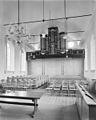
 INTERIEUR, ORGEL - Blankenham - 20277090 - RCE.jpg 1,200 × 948; 175 KB
-
 INTERIEUR, OVERZICHT NAAR HET OOSTEN - Blankenham - 20277088 - RCE.jpg 1,200 × 962; 168 KB
-
 INTERIEUR, OVERZICHT NAAR HET WESTEN MET ORGEL - Blankenham - 20277089 - RCE.jpg 960 × 1,200; 214 KB
-
 INTERIEUR, PREEKSTOEL - Blankenham - 20277092 - RCE.jpg 949 × 1,200; 151 KB
-
 N.H. Kerk van Blankenham.JPG 4,032 × 3,024; 2.36 MB