Category:Hidden Falls (New Zealand)
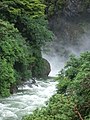
Hidden Falls of Hidden Falls creek, on the Hollyford Track, close to Hidden Falls Hut
| Object location | | View all coordinates using: OpenStreetMap |
|---|
New Zealand waterfall .jpg) | |||||
| Upload media | |||||
| Instance of | |||||
|---|---|---|---|---|---|
| Located in protected area | |||||
| Location | Southland District, Southland Region, New Zealand | ||||
| Height |
| ||||
 | |||||
Media in category "Hidden Falls (New Zealand)"
The following 8 files are in this category, out of 8 total.
-
 Hidden Falls Creek bridge.jpg 2,048 × 1,536; 660 KB
-
 Hidden Falls 2 (NZ).jpg 1,536 × 2,048; 684 KB
-
 Hidden Falls 3 (NZ).jpg 480 × 640; 339 KB
-
 Hidden Falls 4 (NZ).jpg 1,536 × 2,048; 685 KB
-
 Hidden Falls 6 (NZ).jpg 1,536 × 2,048; 702 KB
-
 Hidden Falls 7 (NZ).jpg 480 × 640; 359 KB
-
 Hidden Falls 8 (NZ).jpg 1,536 × 2,048; 688 KB
-
 Hidden Falls 9 (NZ).jpg 1,536 × 2,048; 715 KB

.jpg)
.jpg)
.jpg)
.jpg)
.jpg)
.jpg)