Category:Hispaniae veteris descriptio (Ortelius)
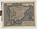
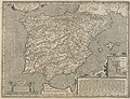
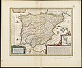
English: This "Description of Old Spain" based on a map from 1586 was repeatedly published until at least 1712, and shows Ortelius' understanding of the Roman province of Hispania. (Unless mapped content of the base map is different from the 1586 version, maps from later dates should not be placed in categories of later decades, even if they were edited by other cartographers)
Media in category "Hispaniae veteris descriptio (Ortelius)"
The following 21 files are in this category, out of 21 total.
-
-
 Hispaniae veteris descriptio - ex conatibus geographicis Abrah. Ortely - btv1b5963769n.jpg 6,048 × 5,032; 5.42 MB
-

-

-
 Map of Spain and inset map of Cadiz by Abraham Ortelius.jpeg 3,055 × 2,345; 2.63 MB
-
 Hispaniae veteris descriptio - btv1b532269733 (1 of 2).jpg 6,614 × 5,282; 5.37 MB
-
-
 Hispaniae veteris descriptio (8343657652).jpg 800 × 662; 130 KB
-
 Hispaniae veteris descriptio - btv1b8443519x.jpg 9,056 × 7,292; 10.89 MB
-
 Hispaniae Veteris Descriptio (FL37099217 2588125).jpg 12,305 × 9,688; 158.45 MB
-
 Hispaniae Veteris Descriptio (FL37099236 2588127).jpg 11,629 × 9,503; 154.53 MB
-
 Hispaniae veteris descriptio - Abraham Goos sculpsit - btv1b59637709.jpg 6,168 × 4,864; 4.52 MB
-
 Abraham Ortelius, Hispaniae veteris descriptio (FL37099248 2588546).jpg 13,369 × 10,867; 213.63 MB
-
 Cartouche met twee hermen, BI-1934-1775-41-5.jpg 1,522 × 832; 247 KB
-

-
-

-

-

-

-


.jpg)
.jpg)

.jpg)
.jpg)
.jpg)

.jpg)
.jpg)

.jpg)

.jpg)
.jpg)
.jpg)
.jpg)
.jpg)
.jpg)
.jpg)