Category:History of Lynton and Lynmouth
Media in category "History of Lynton and Lynmouth"
The following 25 files are in this category, out of 25 total.
-
-
 Duty Point Tower - geograph.org.uk - 739475.jpg 640 × 480; 124 KB
-
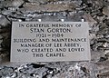
 Lee Abbey Lynton and Lynmouth England.jpg 1,070 × 832; 133 KB
-
 Lee Abbey, Lynton and Lynmouth, England-LCCN2002697015.jpg 3,680 × 2,727; 2.97 MB
-
 Lynton, Ragged Jack Rock, Valley of Rocks.jpg 4,032 × 1,976; 6.29 MB
-
 On the Road to Watersmeet, near Lynton, North Devon MET DP209251.jpg 3,368 × 3,052; 1.89 MB
-
 Ordnance Survey Cut Mark - geograph.org.uk - 3724797.jpg 4,000 × 3,000; 4.39 MB
-
 Ordnance Survey Cut Mark - geograph.org.uk - 4450847.jpg 480 × 640; 99 KB
-
 Ordnance Survey Cut Mark - geograph.org.uk - 4450850.jpg 480 × 640; 106 KB
-
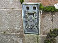
 Ordnance Survey Flush Bracket (S2819) - geograph.org.uk - 4450842.jpg 480 × 640; 112 KB
-
 Ordnance Survey Flush Bracket G4925 - geograph.org.uk - 3724774.jpg 4,000 × 3,000; 3.67 MB
-
 Ordnance Survey Flush Bracket S2819 - geograph.org.uk - 3724878.jpg 4,000 × 3,000; 3.61 MB
-
 Ordnance Survey One-Inch Sheet 118 Barnstaple & Exmoor, Published 1918r.jpg 11,955 × 8,925; 10.5 MB
-
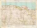
 Ordnance Survey One-Inch Sheet 118 Barnstaple and Exmoor, Published 1919.jpg 12,146 × 8,428; 11.35 MB
-
 Ordnance Survey One-Inch Sheet 119 Exmoor, Published 1918.jpg 12,244 × 8,428; 13.03 MB
-
 Ordnance Survey One-Inch Sheet 119 Exmoor, Published 1918r.jpg 11,862 × 8,926; 10.77 MB
-

-
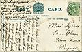
 Stereo card label Lynton Devon 001.jpg 4,192 × 2,021; 7.05 MB
-
 Stereo card label West Lyn 1860s.jpg 4,104 × 2,016; 1.52 MB
-
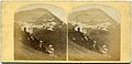 Stereo card Lynton Devon 001.jpg 4,192 × 2,021; 6.68 MB
-
 Stereo card West Lyn Devon 1860s.jpg 4,112 × 2,012; 1.92 MB
-
 W E Palmer Linton 006.jpg 4,121 × 2,034; 7.21 MB
-
 W E Palmer Linton 006a.jpg 2,032 × 4,120; 1.52 MB
-
 W E Palmer Linton 007.jpg 3,296 × 2,116; 2.57 MB
-
 W E Palmer Linton 007a.jpg 3,300 × 2,100; 1.53 MB


_-_geograph.org.uk_-_4450842.jpg)


,_RP-F-F04709.jpg)


