Category:Hochbunker Torstenssonstraße (Hannover)
|
Hochbunker Torstenssonstraße (Hannover) has an entry on OpenStreetMap (show). |
This is the category of the Baudenkmal (cultural heritage monument) High bunker according to the Cultural Heritage Protection Law of Lower Saxony with the ID 42789420 (Wikidata (P7900)).
|
Bunker in Hannover-Oberricklingen, Germany   | |||||
| Upload media | |||||
| Instance of | |||||
|---|---|---|---|---|---|
| Location | Ricklingen, Hanover, Hanover region, Lower Saxony, Germany | ||||
| Located on street | |||||
| Heritage designation | |||||
 | |||||
Deutsch: Zivilschutzbunker (Hochbunker) in der Torstenssonstraße, Hannover-Ricklingen. Erbaut 1942 - 1944, ab 1965 Umbau zu einem ABC-Schutz-Bunker für die Zivilbevölkerung. Kapazität: 2.400 Personen. Heutige Nutzung: Museumsbunker. Betreiber: Vorbei e.V.
English: Civil Defense bunker (high bunker) in the Torstenssonstraße, Hannover-Ricklingen. Built 1942 - 1944, since 1965 conversion to a NBC protective bunkers for civilians. Capacity: 2,400 people. Current use: mueseum bunker. Operator: Vorbei e.V.
Media in category "Hochbunker Torstenssonstraße (Hannover)"
The following 16 files are in this category, out of 16 total.
-
 Hochbunker Torstenssonstraße in Hannover-Oberricklingen 1.jpg 4,032 × 3,024; 2.66 MB
-
 Hochbunker Torstenssonstraße in Hannover-Oberricklingen 2.jpg 4,032 × 3,024; 3.95 MB
-
 Zivilschutzbunker 1 Zugang.JPG 3,264 × 2,448; 3.63 MB
-
 Zivilschutzbunker 10 Büro Bunkerwart.JPG 3,264 × 2,448; 3.52 MB
-
 Zivilschutzbunker 11 Aufenthaltsbereich.JPG 3,264 × 2,448; 3.35 MB
-
 Zivilschutzbunker 12 Sanitätsraum.JPG 3,264 × 2,448; 3.48 MB
-
 Zivilschutzbunker 13 Strahlenschutztür mit Bleikugeln in Schamotte.JPG 2,448 × 3,264; 3.92 MB
-
 Zivilschutzbunker 14 Führung.JPG 3,264 × 2,448; 3.5 MB
-
 Zivilschutzbunker 2 Bedienung der Zugangschleuse.JPG 3,264 × 2,448; 3.41 MB
-
 Zivilschutzbunker 3 Aufenthaltsbereich mit Treppe.jpg 3,264 × 2,448; 3.61 MB
-
 Zivilschutzbunker 4 Liegebereich.jpg 3,264 × 2,448; 4.49 MB
-
 Zivilschutzbunker 5 Küche.JPG 3,264 × 2,448; 3.49 MB
-
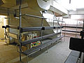
 Zivilschutzbunker 6 Vorräte.JPG 3,264 × 2,448; 3.49 MB
-
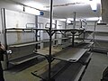
 Zivilschutzbunker 7 Vorräte.JPG 3,264 × 2,448; 3.49 MB
-
 Zivilschutzbunker 8 Vorräte.jpg 3,264 × 2,448; 5.76 MB
-
 Zivilschutzbunker 9 Waschraum Damen.JPG 3,264 × 2,448; 3.45 MB


