Category:Hof van Moerkerken
| Object location | | View all coordinates using: OpenStreetMap |
|---|
building in the Netherlands  | |||||
| Upload media | |||||
| Instance of | |||||
|---|---|---|---|---|---|
| Part of | |||||
| Location | Mijnsheerenland, Hoeksche Waard, South Holland, Netherlands | ||||
| Street address |
| ||||
| Located on street |
| ||||
| Heritage designation |
| ||||
 | |||||
|
This is a category about rijksmonumentcomplex number 514024
|
|
This is a category about rijksmonument number 514025
|
|
This is a category about rijksmonument number 514026
|
|
This is a category about rijksmonument number 514027
|
|
This is a category about rijksmonument number 514028
|
|
This is a category about rijksmonument number 514029
|
|
This is a category about rijksmonument number 514030
|
|
This is a category about rijksmonument number 514031
|
|
This is a category about rijksmonument number 514032
|
|
This is a category about rijksmonument number 514033
|
|
This is a category about rijksmonument number 514034
|
|
This is a category about rijksmonument number 514035
|
|
This is a category about rijksmonument number 514036
|
|
This is a category about rijksmonument number 514037
|
| Address |
|
Subcategories
This category has the following 3 subcategories, out of 3 total.
Media in category "Hof van Moerkerken"
The following 62 files are in this category, out of 62 total.
-
 Achtergevel - Mijnsheerenland - 20159293 - RCE.jpg 1,192 × 1,200; 473 KB
-
 Beschilderde deur in woonkamer - Mijnsheerenland - 20159284 - RCE.jpg 1,193 × 1,200; 220 KB
-
 Bouwhuis - Mijnsheerenland - 20159280 - RCE.jpg 1,200 × 806; 227 KB
-
 Detail van schouw in slaapkamer achter links - Mijnsheerenland - 20159286 - RCE.jpg 1,195 × 1,200; 221 KB
-
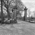 Ingangshek met stenen hekpijlers - Mijnsheerenland - 20159289 - RCE.jpg 1,193 × 1,200; 441 KB
-
 Inrijhek - Mijnsheerenland - 20159277 - RCE.jpg 873 × 1,200; 299 KB
-
 Koetshuis, achtergevel - Mijnsheerenland - 20159296 - RCE.jpg 1,188 × 1,200; 447 KB
-
 Koetshuis, rechter zijgevel - Mijnsheerenland - 20159295 - RCE.jpg 1,190 × 1,200; 412 KB
-
 Koetshuis, voorzijde - Mijnsheerenland - 20159294 - RCE.jpg 1,192 × 1,200; 456 KB
-
 Linker zijgevel - Mijnsheerenland - 20159292 - RCE.jpg 1,192 × 1,200; 468 KB
-
 Mijnsheerenland - Hof van Moerkerken.png 1,375 × 1,032; 1.38 MB
-
 Moerkerken.jpg 2,100 × 1,482; 511 KB
-
 Overzicht achtergevel en linker zijgevel - Mijnsheerenland - 20358377 - RCE.jpg 1,192 × 1,200; 459 KB
-
 Overzicht achtergevel en linker zijgevel - Mijnsheerenland - 20358378 - RCE.jpg 1,186 × 1,200; 376 KB
-
 Overzicht achtergevel en linker zijgevel - Mijnsheerenland - 20358471 - RCE.jpg 1,200 × 1,195; 323 KB
-
 Overzicht achtergevel en linker zijgevel - Mijnsheerenland - 20358474 - RCE.jpg 1,194 × 1,200; 414 KB
-

-

-
 Overzicht exterieur - Mijnsheerenland - 20159278 - RCE.jpg 1,200 × 805; 257 KB
-
 Overzicht inrijpoort met oprijlaan en voorgevel - Mijnsheerenland - 20358375 - RCE.jpg 1,188 × 1,200; 384 KB
-
 Overzicht inrijpoort met oprijlaan en voorgevel - Mijnsheerenland - 20358473 - RCE.jpg 1,198 × 1,200; 384 KB
-

-

-

-

-
 Overzicht van de tuinmuur - Mijnsheerenland - 20424016 - RCE.jpg 1,200 × 798; 289 KB
-
 Overzicht van de tuinmuur - Mijnsheerenland - 20424017 - RCE.jpg 1,200 × 798; 332 KB
-
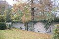 Overzicht van de tuinmuur - Mijnsheerenland - 20424019 - RCE.jpg 1,200 × 798; 374 KB
-

-
-

-

-
-

-

-

-

-

-

-

-

-

-

-

-
 Overzicht van stal - Mijnsheerenland - 20423954 - RCE.jpg 1,200 × 798; 369 KB
-
 Overzicht van stal - Mijnsheerenland - 20423956 - RCE.jpg 1,200 × 798; 375 KB
-
 Overzicht van stal - Mijnsheerenland - 20423957 - RCE.jpg 1,200 × 798; 383 KB
-
 Overzicht van stal met omgeving - Mijnsheerenland - 20423955 - RCE.jpg 1,200 × 798; 390 KB
-
 Rechter zijgevel - Mijnsheerenland - 20159291 - RCE.jpg 1,200 × 1,193; 480 KB
-
 Schouw in grote voorkamer - Mijnsheerenland - 20159281 - RCE.jpg 1,195 × 1,200; 261 KB
-
 Schouw in slaapkamer achter links - Mijnsheerenland - 20159285 - RCE.jpg 1,200 × 1,194; 225 KB
-
 Schouw in voorkamer - Mijnsheerenland - 20159283 - RCE.jpg 1,195 × 1,200; 251 KB
-
 Stucplafond in grote voorkamer - Mijnsheerenland - 20159282 - RCE.jpg 1,191 × 1,200; 204 KB
-
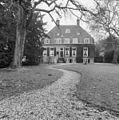
 Voorgevel - Mijnsheerenland - 20159279 - RCE.jpg 1,200 × 806; 261 KB
-
 Voorgevel - Mijnsheerenland - 20159290 - RCE.jpg 1,200 × 929; 325 KB
-
 Voorraad kelder - Mijnsheerenland - 20159287 - RCE.jpg 1,200 × 1,199; 204 KB
-
 Wijnkelder - Mijnsheerenland - 20159288 - RCE.jpg 1,195 × 1,200; 274 KB
-
 Wilhelminastraat66Kasteel.jpg 3,888 × 2,592; 7.29 MB
-
 Wilhelminastraat66Koetshuis.jpg 3,888 × 2,592; 7.36 MB
-
 Wilhelminastraat66Poort.jpg 3,888 × 2,592; 7.76 MB
-
 Wilhelminastraat66Poorta.jpg 2,592 × 3,888; 9.87 MB
-
 Wilhelminastraat66Tuinmuur.jpg 3,888 × 2,592; 6.58 MB


