Category:Hoflaan 1, Mijnsheerenland
| Object location | | View all coordinates using: OpenStreetMap |
|---|
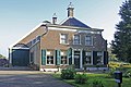
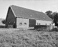
farmhouse in Binnenmaas, Netherlands  | |||||
| Upload media | |||||
| Instance of | |||||
|---|---|---|---|---|---|
| Location | Mijnsheerenland, Hoeksche Waard, South Holland, Netherlands | ||||
| Street address |
| ||||
| Located on street |
| ||||
| Heritage designation |
| ||||
 | |||||
|
This is a category about rijksmonument number 30145
|
| Address |
|
Media in category "Hoflaan 1, Mijnsheerenland"
The following 7 files are in this category, out of 7 total.
-
 Achterzijde schuur - Mijnsheerenland - 20159306 - RCE.jpg 1,200 × 961; 284 KB
-
 Hoflaan1.jpg 3,888 × 2,592; 7.92 MB
-
 Schuur - Mijnsheerenland - 20159304 - RCE.jpg 1,200 × 957; 360 KB
-
 Voorgevel - Mijnsheerenland - 20159301 - RCE.jpg 1,200 × 807; 209 KB
-
 Voorgevel - Mijnsheerenland - 20159302 - RCE.jpg 1,200 × 967; 247 KB
-
 Zijgevel - Mijnsheerenland - 20159303 - RCE.jpg 1,200 × 963; 315 KB
-
 Zijgevel - Mijnsheerenland - 20159305 - RCE.jpg 1,200 × 960; 308 KB


