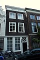
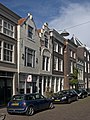
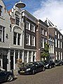
Category:Hoge Nieuwstraat 9, Dordrecht
| Object location | | View all coordinates using: OpenStreetMap |
|---|
 | |||||
| Upload media | |||||
| Instance of |
| ||||
|---|---|---|---|---|---|
| Location | Dordrecht, South Holland, Netherlands | ||||
| Street address |
| ||||
| Heritage designation |
| ||||
 | |||||
|
This is a category about rijksmonument number 13453
|
| Address |
|
Media in category "Hoge Nieuwstraat 9, Dordrecht"
The following 8 files are in this category, out of 8 total.
-
 Dordrecht - Hoge Nieuwstraat 9.JPG 3,056 × 4,592; 3.34 MB
-
 Dordrecht Hoge Nieuwstraat11.jpg 2,736 × 3,648; 5.28 MB
-
 Dordrecht Hoge Nieuwstraat13.jpg 2,736 × 3,648; 5.16 MB
-
 Dordrecht Hoge Nieuwstraat15.jpg 2,736 × 3,648; 5.13 MB
-
 Dordrecht Hoge Nieuwstraat9.jpg 2,736 × 3,648; 5.2 MB
-
 Overzicht - Dordrecht - 20062410 - RCE.jpg 804 × 1,200; 183 KB
-
 Voorgevel - Dordrecht - 20062411 - RCE.jpg 804 × 1,200; 202 KB
-
 Voorgevels - Dordrecht - 20062412 - RCE.jpg 804 × 1,200; 184 KB


