Category:Hogewoerd 63, Leiden
| Object location | | View all coordinates using: OpenStreetMap |
|---|
architectural monument in Leiden  | |||||
| Upload media | |||||
| Instance of |
| ||||
|---|---|---|---|---|---|
| Location | Leiden, South Holland, Netherlands | ||||
| Heritage designation |
| ||||
 | |||||
|
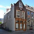
This is a category about rijksmonument number 24821
|
| Address |
|
Media in category "Hogewoerd 63, Leiden"
The following 5 files are in this category, out of 5 total.
-
 2008 Former student digs of the poet Piet Paaltjens.jpg 3,872 × 2,592; 3.74 MB
-
 Gevels - Leiden - 20136109 - RCE.jpg 808 × 1,200; 175 KB
-
 Leiden - Hogewoerd 63 Dio.jpg 1,536 × 1,536; 352 KB
-
 Leiden - Hogewoerd 63 en 61 en 59.JPG 4,592 × 3,056; 4.74 MB
-
 Leiden - Hogewoerd 63.JPG 3,056 × 4,592; 3.46 MB


