Category:Hohe Düne
human settlement in Germany   | |||||
| Upload media | |||||
| Instance of |
| ||||
|---|---|---|---|---|---|
| Part of | |||||
| Location | Rostock, Mecklenburg-Western Pomerania, Germany | ||||
| Area |
| ||||
| Elevation above sea level |
| ||||
 | |||||
Subcategories
This category has the following 8 subcategories, out of 8 total.
- Aerial photographs of Hohe Düne (27 F)
F
L
- Lotsenhaus (Hohe Düne) (18 F)
M
- Marinestützpunkt Hohe Düne (97 F)
P
- Pagenwerder (22 F)
R
- Molenfeuer Ost (Rostock) (34 F)
T
- Tonnenhof Hohe Düne (9 F)
Y
- Yachthafenresidenz Hohe Düne (54 F)
Media in category "Hohe Düne"
The following 73 files are in this category, out of 73 total.
-
 12-06-09-warnemuende-by-ralfr-102.jpg 3,216 × 2,136; 2.75 MB
-
 12-06-09-warnemuende-by-ralfr-105.jpg 3,216 × 2,136; 2.46 MB
-
 12-06-09-warnemuende-by-ralfr-106.jpg 3,216 × 2,136; 3.05 MB
-
 12-06-09-warnemuende-by-ralfr-107.jpg 3,216 × 2,136; 2.96 MB
-
 12-06-09-warnemuende-by-ralfr-108.jpg 3,216 × 2,136; 2.07 MB
-
 12-06-09-warnemuende-by-ralfr-109.jpg 3,216 × 2,136; 2.89 MB
-
 1930 - Standort der Ernst Heinkel Betriebsstätte in Warnemünde Hohe Düne.jpg 1,758 × 868; 384 KB
-

-

-

-
 Bundesarchiv Bild 183-T1013-012, Rostock, Überseehafen, Frachter.jpg 800 × 607; 74 KB
-
 Car ferry Breitling between Warnemünde and Hohe Dune - panoramio.jpg 5,406 × 3,550; 2.16 MB
-
 Copenhagen Ship.jpg 4,000 × 3,000; 3.92 MB
-
 Faehre Warnemuende Breitling.jpg 1,280 × 713; 401 KB
-
 Hanse Sail 2009 - Rostock Warnemünde - Feldjäger.jpg 2,304 × 3,456; 3.51 MB
-
 Hanse Sail 2009 - Rostock Warnemünde - MB G Wolf Feldjäger.jpg 3,456 × 2,304; 2.74 MB
-
 Hohe Düne (23324019674).jpg 5,431 × 3,621; 2.76 MB
-
 Hohe Düne (23325067983).jpg 6,000 × 4,000; 5.01 MB
-
 Hohe Düne (23326345633).jpg 6,000 × 4,000; 4.55 MB
-
 Hohe Düne (23327245884).jpg 6,000 × 4,000; 4.75 MB
-
 Hohe Düne (23350404074).jpg 6,000 × 4,000; 3.21 MB
-
 Hohe Düne (23351804933).jpg 6,000 × 3,453; 3.21 MB
-
 Hohe Düne (23584214239).jpg 6,000 × 4,000; 3.64 MB
-
 Hohe Düne (23584246319).jpg 6,000 × 4,000; 3.09 MB
-
 Hohe Düne (23584377849).jpg 4,000 × 6,000; 2.7 MB
-
 Hohe Düne (23587978029).jpg 6,000 × 4,000; 4.3 MB
-
 Hohe Düne (23656364350).jpg 6,000 × 4,000; 3.67 MB
-
 Hohe Düne (23656393690).jpg 5,369 × 3,579; 2.38 MB
-
 Hohe Düne (23656491970).jpg 6,000 × 4,000; 3.63 MB
-
 Hohe Düne (23656606560).jpg 6,000 × 4,000; 4.6 MB
-
 Hohe Düne (23869375711).jpg 6,000 × 4,000; 3.07 MB
-
 Hohe Düne (23926145896).jpg 6,000 × 4,000; 4.48 MB
-
 Hohe Düne (23926275736).jpg 6,000 × 4,000; 3.85 MB
-
 Hohe Düne (23952080215).jpg 6,000 × 4,000; 3.88 MB
-
 Hohe Düne (23955861835).jpg 6,000 × 4,000; 3.48 MB
-
 Hohe Düne (24041250731).jpg 6,000 × 4,000; 2.85 MB
-
 Hohe Düne bei Rostock 0stsee (49828889243).jpg 3,000 × 2,000; 3.61 MB
-
 Hohe Düne bei Rostock 0stsee (49828890078).jpg 3,000 × 2,000; 5.14 MB
-
 Hohe Düne bei Rostock 0stsee (49828890258).jpg 3,000 × 2,000; 3.49 MB
-
 Hohe Düne bei Rostock 0stsee (49828890438).jpg 3,000 × 2,000; 4.18 MB
-
 Hohe Düne bei Rostock 0stsee (49829420286).jpg 3,000 × 2,000; 5.15 MB
-
 Hohe Düne bei Rostock 0stsee (49829421531).jpg 3,000 × 2,000; 3.8 MB
-
 Hohe Düne bei Rostock 0stsee (49829421681).jpg 3,000 × 2,000; 3.87 MB
-
 Hohe Düne bei Rostock 0stsee (49829421851).jpg 3,000 × 2,000; 3.39 MB
-
 Hohe Düne bei Rostock 0stsee (49829422696).jpg 3,000 × 2,000; 5.26 MB
-
 Hohe Düne bei Rostock 0stsee (49829422936).jpg 3,000 × 2,000; 5.16 MB
-
 Hohe Düne bei Rostock 0stsee (49829730967).jpg 3,000 × 2,000; 6.27 MB
-
 Hohe Düne bei Rostock 0stsee (49829731122).jpg 3,000 × 2,000; 4.37 MB
-
 Hohe Düne bei Rostock 0stsee (49829731942).jpg 3,000 × 2,000; 3.97 MB
-
 Hohe Düne bei Rostock 0stsee (49829732657).jpg 3,000 × 2,000; 6.15 MB
-
 Hohe Düne bei Rostock 0stsee (49829732832).jpg 3,000 × 2,000; 4.29 MB
-
 Hohe Düne bei Rostock 0stsee (49829732952).jpg 3,000 × 2,000; 3.55 MB
-
 Hohe Düne Hafenpromenade.jpg 4,000 × 3,000; 4.55 MB
-
 Hohe Düne in Rostock.svg 1,380 × 1,380; 427 KB
-
 Hohe Düne, Rostock, Germany - panoramio (1).jpg 3,648 × 2,736; 5.15 MB
-
 Hohe Düne, Rostock, Germany - panoramio (2).jpg 3,648 × 2,621; 3.45 MB
-
 Hohe Düne, Rostock, Germany - panoramio.jpg 3,648 × 2,736; 5.22 MB
-
 Hohe Düne.jpg 5,884 × 3,857; 13.79 MB
-
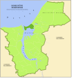 Hohe Düne.svg 2,375 × 2,594; 135 KB
-
 Insel vor Rostock.JPG 2,581 × 1,427; 1.19 MB
-
 Norddeutsche Philharmonie Rostock 2009.jpg 3,008 × 2,000; 2.94 MB
-
 Rauhreif auf Bäumen an der Küste.jpg 4,482 × 3,056; 5.36 MB
-
 Rostock Blick über den Hafen auf den Ort 3.JPG 2,660 × 1,875; 2.73 MB
-
 Rostock Ortsteile Hohe Düne.PNG 706 × 788; 66 KB
-
 Rostock Robbenzentrrum und Fähre.JPG 3,690 × 1,692; 3.67 MB
-
 Rostock Warnemuende Lotsenstation 2011-05-17.jpg 1,615 × 2,154; 1.58 MB
-
 Rostock Warnemünde Sedov 2014-03-12.jpg 3,380 × 2,536; 4.87 MB
-
 Seenotretter Pilot in Rostock, 2012.jpg 4,072 × 2,737; 6.29 MB
-
 Warnemuende 2010-by-RaBoe-01.jpg 1,111 × 739; 703 KB
-
 Warnemuende 2010-by-RaBoe-22.jpg 1,111 × 739; 880 KB
-
 Warnemünde 1877.jpg 1,622 × 1,729; 1.07 MB
-
 Warnemünde Panorama von Osten.jpg 9,121 × 1,745; 4.85 MB
-
 Warnemünde, Rostock, Germany - panoramio (34).jpg 3,648 × 2,736; 5.05 MB


.jpg)

.jpg)


.jpg)
.jpg)
.jpg)
.jpg)
.jpg)
.jpg)
.jpg)
.jpg)
.jpg)
.jpg)
.jpg)
.jpg)
.jpg)
.jpg)
.jpg)
.jpg)
.jpg)
.jpg)
.jpg)
.jpg)
.jpg)
.jpg)
.jpg)
.jpg)
.jpg)
.jpg)
.jpg)
.jpg)
.jpg)
.jpg)
.jpg)
.jpg)
.jpg)
.jpg)
.jpg)
.jpg)

.jpg)
.jpg)


.jpg)