Category:Hoofdstraat 122, Driebergen-Rijsenburg
| Object location | | View all coordinates using: OpenStreetMap |
|---|
building in Utrechtse Heuvelrug, Netherlands  | |||||
| Upload media | |||||
| Instance of | |||||
|---|---|---|---|---|---|
| Location | Driebergen-Rijsenburg, Utrecht, Netherlands | ||||
| Street address |
| ||||
| Located on street | |||||
| Heritage designation |
| ||||
 | |||||
|
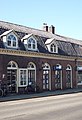
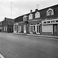
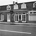
This is a category about rijksmonument number 14088
|
| Address |
|
Media in category "Hoofdstraat 122, Driebergen-Rijsenburg"
The following 8 files are in this category, out of 8 total.
-
 Gevels, overzicht - Rijsenburg - 20187546 - RCE.jpg 1,200 × 820; 155 KB
-
 Overzicht - Rijsenburg - 20187536 - RCE.jpg 1,191 × 1,200; 313 KB
-
 RM14088 Hoofdstraat 122.JPG 2,940 × 4,320; 1.26 MB
-
 Voor- en zijgevel - Rijsenburg - 20187539 - RCE.jpg 1,195 × 1,200; 331 KB
-
 Voorgevel - Driebergen-Rijsenburg - 20063965 - RCE.jpg 1,200 × 949; 247 KB
-
 Voorgevel - Rijsenburg - 20187537 - RCE.jpg 1,198 × 1,200; 294 KB
-
 Voorgevel - Rijsenburg - 20187538 - RCE.jpg 1,200 × 1,200; 351 KB
-
 Voorgevels - Driebergen-Rijsenburg - 20063964 - RCE.jpg 1,200 × 947; 236 KB


