Category:Hooglandse Kerkgracht 22, Leiden
| Object location | | View all coordinates using: OpenStreetMap |
|---|
building in Leiden, Netherlands  | |||||
| Upload media | |||||
| Instance of | |||||
|---|---|---|---|---|---|
| Location | Leiden, South Holland, Netherlands | ||||
| Located on street | |||||
| Heritage designation |
| ||||
 | |||||
Tuinhuis:
|
This is a category about a municipal monument in Leiden with number 1760 |
Huis:
|
This is a category about rijksmonument number 24909
|
| Address |
|
Media in category "Hooglandse Kerkgracht 22, Leiden"
The following 5 files are in this category, out of 5 total.
-
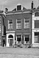 Gevel - Leiden - 20136171 - RCE.jpg 803 × 1,200; 186 KB
-
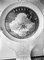 Interieur, geschilderd plafond in achterkamer - Leiden - 20136169 - RCE.jpg 888 × 1,200; 192 KB
-
 Interieur, geschilderd plafond in voorkamer - Leiden - 20136168 - RCE.jpg 1,200 × 890; 220 KB
-
 Leiden - Hooglandse kerkgracht 22.JPG 2,736 × 3,648; 3.84 MB
-
 Leiden s 11 L Pancrast west GM Hooglandse kerkgracht 22 Tuinhuis 23062020.jpg 3,000 × 4,000; 4.29 MB


