Category:Hoogstraat 44, Nieuwpoort
| Object location | | View all coordinates using: OpenStreetMap |
|---|
building in Molenwaard, Netherlands  | |||||
| Upload media | |||||
| Instance of | |||||
|---|---|---|---|---|---|
| Location | Nieuwpoort, South Holland, Netherlands | ||||
| Street address |
| ||||
| Located on street |
| ||||
| Heritage designation |
| ||||
 | |||||
|
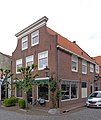
This is a category about rijksmonument number 30597
|
| Address |
|
Media in category "Hoogstraat 44, Nieuwpoort"
The following 4 files are in this category, out of 4 total.
-
 Aanzicht - Nieuwpoort - 20165829 - RCE.jpg 1,200 × 811; 233 KB
-
 Nieuwpoort Hoogstraat 44.jpg 3,138 × 3,732; 3.9 MB
-
 RM30597 Nieuwpoort - Hoogstraat 44.jpg 1,944 × 2,592; 1.7 MB
-
 Voor- en rechter zijgevel - Nieuwpoort - 20165830 - RCE.jpg 1,195 × 1,200; 307 KB


