Category:Horfield (ward)
electoral ward of the unitary authority of Bristol  | |||||
| Upload media | |||||
| Instance of |
| ||||
|---|---|---|---|---|---|
| Location | City of Bristol, South West England, England | ||||
| Different from | |||||
| |||||
Subcategories
This category has the following 6 subcategories, out of 6 total.
H
- Horfield Parish Church (9 F)
- Horfield railway station (7 F)
S
- Southmead Hospital (29 F)
- St Gregory Church, Horfield (5 F)
Media in category "Horfield (ward)"
The following 30 files are in this category, out of 30 total.
-
 2018 at Horfield - relaying the main line (03).JPG 1,366 × 910; 422 KB
-
 2018 at Horfield - relaying the main line (12).JPG 1,366 × 820; 504 KB
-
 2018 at Horfield - relaying the main line (21).JPG 1,366 × 910; 616 KB
-
 2018 at Horfield - relaying the main line (22) (66221).JPG 1,366 × 910; 688 KB
-
 2018 at Horfield - relaying the main line (23) 66221.JPG 1,366 × 910; 885 KB
-
 2018 at Horfield - the four tracks now in place (01).JPG 1,366 × 910; 389 KB
-
 Avenue of small trees along a path - geograph.org.uk - 135735.jpg 480 × 640; 220 KB
-
 Bristol bus stop skeleton.jpg 2,448 × 3,264; 1.77 MB
-
 Bristol horfield.png 702 × 780; 148 KB
-
 Horfield - CrossCountry 220010 northbound.JPG 1,366 × 910; 516 KB
-
 Horfield balloon.jpg 2,288 × 1,712; 1.3 MB
-
 Horfield Barracks 2.jpg 1,400 × 880; 800 KB
-
 Horfield Barracks.jpg 800 × 516; 50 KB
-
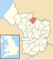 Horfield Bristol UK ward map.svg 1,138 × 1,266; 709 KB
-
 Horfield Leisure Centre (geograph 5679298).jpg 2,886 × 1,722; 339 KB
-
 Horfield Leisure Centre - geograph.org.uk - 94606.jpg 640 × 480; 122 KB
-
 Horfield Lockleaze Road - First 66935 (WX55UAB).JPG 1,366 × 820; 235 KB
-
 Horfield United Reformed Church - geograph.org.uk - 101468.jpg 640 × 480; 132 KB
-
 Horfield, Kenmore Crescent - geograph.org.uk - 2535833.jpg 1,024 × 683; 122 KB
-
 Hugh llewelyn 5029 (6238716702).jpg 3,872 × 2,592; 2.31 MB
-
 Hugh llewelyn 5029 (6238716710).jpg 2,560 × 1,705; 477 KB
-
 Monks Park.jpg 500 × 334; 209 KB
-
 Monksparkschool.jpg 640 × 480; 252 KB
-
 Monksparkschoolnew.jpg 640 × 480; 96 KB
-

-

-
 Wessex Avenue, Horfield - geograph.org.uk - 101462.jpg 480 × 640; 81 KB
-
 Weston Crescent, Horfield - geograph.org.uk - 148011.jpg 640 × 480; 140 KB
-
 Manor Farm Boys Club, Horfield - geograph.org.uk - 156460.jpg 640 × 480; 425 KB
-
 Territorial Army, Horfield - geograph.org.uk - 146495.jpg 640 × 480; 216 KB
.JPG)
.JPG)
.JPG)
_(66221).JPG)
_66221.JPG)
.JPG)


.jpg)

.JPG)


.jpg)
.jpg)


_in_Horfield,_on_Christmas_Day_-_geograph.org.uk_-_95305.jpg)


