Category:Horse Mesa Dam
concrete thin arch dam located in the Superstition Mountains  | |||||
| Upload media | |||||
| Instance of | |||||
|---|---|---|---|---|---|
| Located in protected area | |||||
| Location |
| ||||
| Located in or next to body of water | |||||
| Service entry |
| ||||
| Inception |
| ||||
| Nominal power capacity |
| ||||
| Length |
| ||||
| Elevation above sea level |
| ||||
| Drainage basin |
| ||||
| Reservoir created | |||||
 | |||||
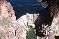
English: Horse Mesa Dam — forming Apache Lake on the Salt River, in the Superstition Mountains, Maricopa County, Arizona.
- Completed in 1927 as a component of the Salt River Project.
Subcategories
This category has only the following subcategory.
H
- Horse Mesa Dam (HAER images) (65 F)
Media in category "Horse Mesa Dam"
The following 8 files are in this category, out of 8 total.
-
 Horse Mesa Dam.jpg 350 × 232; 30 KB
-
 AZ Maricopa County Salt River ProjectMPS Horse Mesa Dam 0001 (24052712748).jpg 2,912 × 2,699; 1.13 MB
-
 AZ Maricopa County Salt River ProjectMPS Horse Mesa Dam 0002 (37856081646).jpg 3,441 × 2,401; 1.22 MB
-
 AZ Maricopa County Salt River ProjectMPS Horse Mesa Dam 0003 (37856049746).jpg 3,648 × 2,736; 1.59 MB
-
 AZ Maricopa County Salt River ProjectMPS Horse Mesa Dam 0007 (24052649088).jpg 3,648 × 2,736; 1.06 MB
-
 AZ Maricopa County Salt River ProjectMPS Horse Mesa Dam 0008 (37904646851).jpg 3,133 × 2,406; 1.08 MB
-
 AZ Maricopa County Salt River ProjectMPS Horse Mesa Dam Historic0005 (37904679761).jpg 2,724 × 1,980; 772 KB
-
 Horse Mesa Dam Spillway.jpg 1,143 × 2,000; 340 KB
.jpg)
.jpg)
.jpg)
.jpg)
.jpg)
.jpg)
