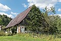
Category:House number 6 in Różanka
| Object location | | View all coordinates using: OpenStreetMap |
|---|
house in Poland  | |||||
| Upload media | |||||
| Instance of | |||||
|---|---|---|---|---|---|
| Location | Różanka, Lower Silesian Voivodeship, Gmina Międzylesie, Kłodzko County, Lower Silesian Voivodeship, Poland | ||||
| Heritage designation |
| ||||
| Inception |
| ||||
 | |||||
Media in category "House number 6 in Różanka"
The following 3 files are in this category, out of 3 total.
-
 2017 Dom nr 6 w Różance 1.jpg 4,754 × 3,300; 12.85 MB
-
 2017 Dom nr 6 w Różance 2.jpg 4,635 × 3,090; 11.27 MB
-
 2017 Dom nr 6 w Różance 3.jpg 4,760 × 3,226; 12.26 MB

