Category:Hudswell, North Yorkshire
village in the United Kingdom  | |||||
| Upload media | |||||
| Instance of | |||||
|---|---|---|---|---|---|
| Location | Richmondshire, North Yorkshire, Yorkshire and the Humber, England | ||||
 | |||||
English: Hudswell is a village and civil parish on the border of the Yorkshire Dales, in the Richmondshire district of North Yorkshire, England. It lies about 3 miles west of Richmond.
Media in category "Hudswell, North Yorkshire"
The following 71 files are in this category, out of 71 total.
-
 A Milestone - geograph.org.uk - 1050203.jpg 640 × 480; 69 KB
-
 A Milestone - geograph.org.uk - 1050221.jpg 640 × 480; 112 KB
-

-
 A6108 at Hag Wood - geograph.org.uk - 5255347.jpg 1,024 × 683; 287 KB
-
 A6108 in the Swale Valley - geograph.org.uk - 5131711.jpg 2,956 × 1,716; 955 KB
-
 A6108 near Marske - geograph.org.uk - 2193914.jpg 640 × 481; 76 KB
-
 A6108 near West Wood - geograph.org.uk - 5255128.jpg 1,024 × 683; 298 KB
-
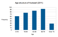 Age structure of Hudswell (2011).png 629 × 407; 30 KB
-

-
 Benchmark on gatepost beside A6108 - geograph.org.uk - 5255142.jpg 683 × 1,024; 229 KB
-

-

-
 Benchmark on Lownethwaite Bridge - geograph.org.uk - 5255763.jpg 1,024 × 665; 251 KB
-
 Benchmark on Thorpe House Farm - geograph.org.uk - 5255258.jpg 683 × 1,024; 249 KB
-

-
 Bridge over Badger Beck - geograph.org.uk - 3844987.jpg 480 × 640; 173 KB
-
 Brokes Close - geograph.org.uk - 4482386.jpg 4,000 × 2,250; 2.09 MB
-
 Cattle Grid and Tank Crossing, Downholme Moor - geograph.org.uk - 4449872.jpg 4,000 × 2,660; 3.71 MB
-
 Farm track passing woodland at Thorpe House - geograph.org.uk - 5255273.jpg 1,024 × 683; 216 KB
-
 Field gates on north side of A6108 at Applegarth - geograph.org.uk - 5255325.jpg 1,024 × 683; 226 KB
-
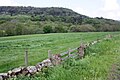
 Fields to the River Swale - geograph.org.uk - 1412060.jpg 640 × 480; 115 KB
-

-
 Footbridge over Church Gill - geograph.org.uk - 4740731.jpg 1,024 × 768; 392 KB
-
 Footpath passing 'Under Bank' - geograph.org.uk - 5255509.jpg 1,024 × 683; 288 KB
-
 Footpath to 'Under Bank' from the A6108 - geograph.org.uk - 5255492.jpg 683 × 1,024; 324 KB
-
 Footpath to St Michael's church - geograph.org.uk - 4740732.jpg 800 × 600; 140 KB
-
 Ford at Coalsgarth Gate - geograph.org.uk - 1710591.jpg 2,048 × 1,536; 2.45 MB
-
 Former gateway to field on north side of A6108 - geograph.org.uk - 5255215.jpg 1,024 × 683; 245 KB
-
 Freshly re-surfaced - geograph.org.uk - 2029494.jpg 3,296 × 2,472; 1.92 MB
-
-
 Gateway in wall beside A6108 opposite West Wood - geograph.org.uk - 5255163.jpg 1,024 × 683; 234 KB
-
 Green Lane - geograph.org.uk - 4601585.jpg 4,320 × 3,240; 4.71 MB
-
 Heron, River Swale - geograph.org.uk - 2193800.jpg 481 × 640; 95 KB
-
 Hudswell St Michael, foundation stone - geograph.org.uk - 4740727.jpg 640 × 480; 151 KB
-
 Hudswell St Michael, path from the old vicarage - geograph.org.uk - 4740695.jpg 1,024 × 768; 423 KB
-
 Leaving Hudswell - geograph.org.uk - 2757997.jpg 3,748 × 2,811; 4.49 MB
-
 Lownethwaite Bridge - geograph.org.uk - 1058626.jpg 640 × 480; 129 KB
-

-
 Meadowland at Middlemoor Farm - geograph.org.uk - 4601601.jpg 4,056 × 2,160; 1.55 MB
-
 Meadowland west of Hudswell - geograph.org.uk - 4601578.jpg 4,320 × 3,240; 2.53 MB
-
 Middlemoor Farm - geograph.org.uk - 4482428.jpg 4,000 × 2,250; 1.49 MB
-
 Milepost, A6108 - geograph.org.uk - 2193932.jpg 640 × 480; 102 KB
-
 Military land above Thorpe Edge - geograph.org.uk - 4601553.jpg 4,320 × 3,240; 2.46 MB
-
 New plantation in Lower Swaledale - geograph.org.uk - 4740728.jpg 1,024 × 768; 183 KB
-
 Occupational Structure of Hudswell, North Yorkshire - 1881.png 430 × 284; 34 KB
-
 Pasture beside a bend in the River Swale - geograph.org.uk - 5997479.jpg 1,600 × 1,067; 269 KB
-
 Pasture on the flood plain of the River Swale - geograph.org.uk - 5997491.jpg 1,600 × 1,038; 305 KB
-
 Path to Thorpe under Stones - geograph.org.uk - 4601560.jpg 3,240 × 4,320; 4.42 MB
-
 Population of Hudswell, North Yorkshire (1881-2011).png 697 × 386; 34 KB
-
 Population of Hudswell, North Yorkshire 1881-1961.JPG 639 × 396; 33 KB
-
 Population of Hudswell, North Yorkshire 1881-1961.png 721 × 394; 34 KB
-
 River Swale - geograph.org.uk - 5243002.jpg 1,499 × 740; 1.06 MB
-
 River Swale - geograph.org.uk - 5997483.jpg 1,600 × 1,067; 395 KB
-
 River Swale in spate - geograph.org.uk - 6088862.jpg 1,600 × 1,067; 371 KB
-
 River Swale near Hudswell - geograph.org.uk - 2193689.jpg 640 × 481; 86 KB
-
 Sand Beck - geograph.org.uk - 4601611.jpg 3,240 × 4,320; 5.37 MB
-
 Sand Beck Bridge - geograph.org.uk - 2029499.jpg 3,296 × 2,472; 1.85 MB
-
 Sand Beck Gill - geograph.org.uk - 2029502.jpg 3,296 × 2,472; 1.95 MB
-
 Sharp bends at Hag Wood - geograph.org.uk - 3079863.jpg 640 × 472; 88 KB
-
 St Michael's Bridge - geograph.org.uk - 1510878.jpg 480 × 640; 136 KB
-
 St.Michael and All Angels , Hudswell - geograph.org.uk - 207144.jpg 640 × 479; 91 KB
-
 Swaledale above Richmond - geograph.org.uk - 2800282.jpg 1,024 × 658; 187 KB
-
 The River Swale - geograph.org.uk - 5955159.jpg 1,600 × 1,067; 411 KB
-

-

-
 Thistles are what Eeyore likes best - geograph.org.uk - 4601571.jpg 4,320 × 3,240; 3.31 MB
-
 Thorpe House Farm - geograph.org.uk - 5255266.jpg 1,024 × 683; 175 KB
-
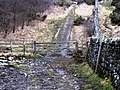
 Track on Hudswell Moor - geograph.org.uk - 4601593.jpg 3,240 × 4,320; 3.95 MB
-
 Two sheds^ - geograph.org.uk - 4482415.jpg 4,000 × 2,247; 3.05 MB
-
 View from Round Howe - geograph.org.uk - 950234.jpg 640 × 480; 142 KB
-
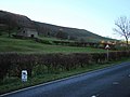
 West end of Hudswell village - geograph.org.uk - 4740734.jpg 1,024 × 768; 281 KB


.png)


.png)


