Category:Hugill
civil parish in England  | |||||
| Upload media | |||||
| Instance of | |||||
|---|---|---|---|---|---|
| Location | South Lakeland, Cumbria, North West England, England | ||||
| Population |
| ||||
 | |||||
Subcategories
This category has the following 5 subcategories, out of 5 total.
Media in category "Hugill"
The following 142 files are in this category, out of 142 total.
-
 A wood pile - geograph.org.uk - 3201453.jpg 3,200 × 2,400; 2.37 MB
-
 A591 approaching Ings - geograph.org.uk - 3068338.jpg 3,237 × 2,324; 2.83 MB
-
 A591, Reston - geograph.org.uk - 3384693.jpg 640 × 480; 500 KB
-

-
 Bridleway - geograph.org.uk - 3330132.jpg 640 × 480; 107 KB
-
 Bridleway across Mickle Moss - geograph.org.uk - 2129058.jpg 640 × 426; 274 KB
-
 Bridleway alongside Mickle Moss - geograph.org.uk - 6021728.jpg 1,499 × 875; 1.28 MB
-
 Bridleway approaching gate - geograph.org.uk - 6019882.jpg 1,500 × 930; 1.3 MB
-
 Bridleway at the end of Browfoot Lane - geograph.org.uk - 3542128.jpg 1,000 × 750; 491 KB
-

-
 Bridleway from The Heights - geograph.org.uk - 3542131.jpg 1,000 × 750; 1.06 MB
-
 Bridleway in Whasdike Wood - geograph.org.uk - 4422864.jpg 640 × 446; 264 KB
-
 Bridleway junction - geograph.org.uk - 3542003.jpg 1,216 × 912; 645 KB
-
 Bridleway junction near High House - geograph.org.uk - 2129056.jpg 640 × 426; 268 KB
-
 Bridleway to High House - geograph.org.uk - 2421863.jpg 480 × 640; 101 KB
-
 Bridleway to Kentmere Hall - geograph.org.uk - 2129062.jpg 640 × 426; 254 KB
-
 Bridleway to The Heights - geograph.org.uk - 2129057.jpg 640 × 426; 265 KB
-
 Bridleway to the River Kent - geograph.org.uk - 3939001.jpg 4,320 × 3,240; 4.54 MB
-
 Browfoot - geograph.org.uk - 3330137.jpg 640 × 480; 76 KB
-
 Browfoot beyond the pasture - geograph.org.uk - 5413052.jpg 1,600 × 1,273; 466 KB
-
 Browfoot Lane - geograph.org.uk - 1212538.jpg 640 × 480; 120 KB
-
 Browfoot Lane - geograph.org.uk - 1548652.jpg 640 × 480; 84 KB
-
 Browfoot, Kentmere valley.jpg 4,608 × 3,456; 5.91 MB
-
 Buildings at Browfoot - geograph.org.uk - 6019809.jpg 1,500 × 1,035; 1.4 MB
-
 Calf and mother in Grassgarth - geograph.org.uk - 3384692.jpg 3,872 × 2,592; 4.54 MB
-
 Cattle grazing near Ings - geograph.org.uk - 1984598.jpg 1,600 × 1,200; 576 KB
-
 Cottages by Reston Hall - geograph.org.uk - 3513459.jpg 3,872 × 2,592; 5.09 MB
-
 Cottages in Grassgarth - geograph.org.uk - 3384686.jpg 3,872 × 2,592; 4.36 MB
-
 Croft Head - geograph.org.uk - 5455580.jpg 3,648 × 2,432; 5.75 MB
-
 Croft Head, Kentmere valley.jpg 4,608 × 3,456; 4.79 MB
-
 Derelict cottage by Black Beck - geograph.org.uk - 1983872.jpg 640 × 480; 88 KB
-
 Descending off Capple How - geograph.org.uk - 1983863.jpg 640 × 480; 72 KB
-
 Eastbound A591 near Reston - geograph.org.uk - 3384695.jpg 640 × 480; 523 KB
-
 Eastbound A591 near Staveley - geograph.org.uk - 3384707.jpg 640 × 480; 505 KB
-
 Elphowe Lane branches off the main road - geograph.org.uk - 5455609.jpg 3,648 × 2,432; 4.29 MB
-
 Equestrian centre at Hill Farm - geograph.org.uk - 3384699.jpg 3,872 × 2,592; 3.82 MB
-
 Farmland at Goose Howe Farm - geograph.org.uk - 5342306.jpg 2,592 × 1,944; 1.29 MB
-
 Farmland at The Heights - geograph.org.uk - 5342303.jpg 2,592 × 1,944; 1.62 MB
-
 Farmland Near Heaning - geograph.org.uk - 5749549.jpg 640 × 381; 59 KB
-
 Field north of bridleway - geograph.org.uk - 3541994.jpg 1,216 × 912; 744 KB
-
 Fields above Browfoot - geograph.org.uk - 5342271.jpg 2,592 × 1,944; 1.91 MB
-
 Fields by Goose Howe - geograph.org.uk - 3542126.jpg 1,000 × 750; 1.07 MB
-
 Fields near Goose Howe - geograph.org.uk - 5455602.jpg 3,648 × 2,432; 5.01 MB
-
 Fields near Heaning - geograph.org.uk - 3385678.jpg 3,872 × 2,592; 3.5 MB
-
 Fields north of High Borrans - geograph.org.uk - 3330123.jpg 640 × 480; 38 KB
-
 Following the contour - geograph.org.uk - 5455593.jpg 3,648 × 2,432; 6.09 MB
-
 Footbridge over the River Gowan - geograph.org.uk - 4019075.jpg 480 × 640; 207 KB
-
 Footpath to Whasdike Farm - geograph.org.uk - 2340039.jpg 640 × 426; 396 KB
-
 Ford, hut and Acretarn Plantation - geograph.org.uk - 3939005.jpg 3,240 × 4,320; 4.68 MB
-
 Ford, Park Beck - geograph.org.uk - 1983867.jpg 480 × 640; 163 KB
-
 Gap in Wall, Capple Howe - geograph.org.uk - 2068313.jpg 640 × 427; 295 KB
-
 Gate in dry stone wall - geograph.org.uk - 6020463.jpg 1,500 × 1,015; 1.43 MB
-
 Goose Howe - geograph.org.uk - 5413335.jpg 1,600 × 1,067; 626 KB
-
 Goose Howe, lower Kentmere - geograph.org.uk - 3255035.jpg 960 × 531; 83 KB
-

-
 High House Farm - geograph.org.uk - 2129016.jpg 640 × 426; 261 KB
-
 Highland Cows by the road to Kentmere - geograph.org.uk - 5688269.jpg 3,264 × 2,448; 1.61 MB
-
 House north of Ulthwaite Bridge - geograph.org.uk - 5455582.jpg 3,648 × 2,432; 5.11 MB
-
 Hugill , A591 - geograph.org.uk - 6353094.jpg 6,000 × 4,000; 5.92 MB
-
 Hugill , Country Lane - geograph.org.uk - 6353086.jpg 6,000 × 4,000; 7.56 MB
-
 Hugill , Country Lane - geograph.org.uk - 6353088.jpg 6,000 × 4,000; 5.8 MB
-
 Hugill , Farm Buildings - geograph.org.uk - 6353087.jpg 6,000 × 4,000; 5.28 MB
-
 Hugill , Grassy Field - geograph.org.uk - 6353083.jpg 6,000 × 4,000; 4.77 MB
-
 Hugill , Road - geograph.org.uk - 6353093.jpg 6,000 × 4,000; 7.2 MB
-
 Hugill Hall - geograph.org.uk - 5017611.jpg 480 × 640; 126 KB
-
 Hungry sheep following me - geograph.org.uk - 3384672.jpg 3,872 × 2,592; 3.24 MB
-
 Ings , A591 - geograph.org.uk - 6353091.jpg 6,000 × 4,000; 4.97 MB
-
 Ings , Grassgarth Lane - geograph.org.uk - 6353090.jpg 6,000 × 4,000; 7.79 MB
-
 Ings, Hill Farm - geograph.org.uk - 3384682.jpg 640 × 427; 444 KB
-
 Kemp Tarn, Reston Scar - geograph.org.uk - 3256252.jpg 640 × 480; 77 KB
-
 Lane to Browfoot and Croft Head - geograph.org.uk - 1525593.jpg 640 × 426; 336 KB
-
 Lane to High House farm - geograph.org.uk - 2129065.jpg 640 × 426; 357 KB
-
 Large tree on Hugill Fell - geograph.org.uk - 3255067.jpg 800 × 600; 178 KB
-
 Line of trees alongside wall - geograph.org.uk - 6021990.jpg 1,500 × 905; 1.51 MB
-
 Looking down on Staveley - geograph.org.uk - 5342433.jpg 2,592 × 1,944; 1.45 MB
-
 Looking down on the A591 - geograph.org.uk - 5342427.jpg 2,592 × 1,944; 1.22 MB
-
 Looking west from Reston Scar - geograph.org.uk - 3256669.jpg 800 × 600; 122 KB
-
 Low and Middle Elfhowe - geograph.org.uk - 5342335.jpg 2,592 × 1,944; 1.2 MB
-
 Marsh with rocks and dry stone walls - geograph.org.uk - 6019925.jpg 1,500 × 1,125; 1.67 MB
-
 Modern houses on the north of Staveley - geograph.org.uk - 3254651.jpg 595 × 800; 143 KB
-
 Narrow country lane to the south-west of Ings - geograph.org.uk - 4142720.jpg 2,048 × 1,536; 744 KB
-
 New sign on Browfoot Fell - geograph.org.uk - 1212541.jpg 640 × 480; 48 KB
-
 Northern entry into Staveley - geograph.org.uk - 3542579.jpg 1,000 × 750; 577 KB
-
 Old barn at Croft Head - geograph.org.uk - 5455579.jpg 3,648 × 2,432; 6.11 MB
-
 On the bridleway to Whasdike - geograph.org.uk - 3076447.jpg 640 × 480; 79 KB
-
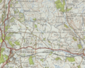 Ordnance Survey of Hugill Civil Parish.PNG 731 × 583; 1.09 MB
-
 Park Beck - geograph.org.uk - 3330069.jpg 640 × 480; 67 KB
-
 Pastureland north of Grassgarth - geograph.org.uk - 4019330.jpg 800 × 600; 146 KB
-
 Pastures near Hill Farm - geograph.org.uk - 2421853.jpg 640 × 480; 98 KB
-
 Path to Grassgarth - geograph.org.uk - 3384678.jpg 3,872 × 2,592; 4.76 MB
-
 Pool Scar - geograph.org.uk - 5413047.jpg 1,600 × 1,067; 462 KB
-
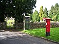 Post box and Telephone kiosk - geograph.org.uk - 3172346.jpg 4,000 × 3,000; 4.37 MB
-
 Public bridleway at High House - geograph.org.uk - 4018034.jpg 640 × 480; 90 KB
-
 Public Bridleway to Grassgarth - geograph.org.uk - 2068320.jpg 640 × 427; 285 KB
-
 Railway bridge over minor road near to Ings - geograph.org.uk - 6178360.jpg 1,600 × 1,066; 552 KB
-
 Recently-cut grassland, Ings - geograph.org.uk - 1984602.jpg 1,600 × 1,200; 461 KB
-
 River Kent from Ulthwaite Bridge - geograph.org.uk - 3330140.jpg 640 × 480; 79 KB
-
 River Kent on the edge of Stavely - geograph.org.uk - 5688386.jpg 1,600 × 1,200; 552 KB
-
 Road and bridleway descending to Ullthwaite Bridge - geograph.org.uk - 6019669.jpg 1,500 × 2,000; 4.09 MB
-
 Road leading past High Fairbank - geograph.org.uk - 4142707.jpg 2,048 × 1,536; 856 KB
-
 Road through Whitehowe Wood - geograph.org.uk - 5455598.jpg 3,648 × 2,432; 5.84 MB
-
 Road to Croft Head - geograph.org.uk - 5455583.jpg 3,648 × 2,432; 4.79 MB
-
 Road to Kentmere - geograph.org.uk - 2324140.jpg 640 × 426; 409 KB
-
 Rocks protruding from grass - geograph.org.uk - 6178340.jpg 1,600 × 763; 327 KB
-
 Rough pasture on Hugill Fell - geograph.org.uk - 3255073.jpg 640 × 480; 99 KB
-
 Roughly vegetated enclosure - geograph.org.uk - 6019793.jpg 1,500 × 877; 1.16 MB
-
 Ruin and fields above Browfoot - geograph.org.uk - 5457432.jpg 1,024 × 682; 981 KB
-
 Ruin, Browfoot - geograph.org.uk - 1548656.jpg 640 × 480; 71 KB
-
 Sheep hiding under Goose Howe - geograph.org.uk - 5455605.jpg 2,608 × 1,739; 1.95 MB
-
 Sheep on the edge of Staveley - geograph.org.uk - 3513422.jpg 3,872 × 2,592; 5.14 MB
-
 Sheep pasture, west of Ings - geograph.org.uk - 5817747.jpg 1,024 × 768; 173 KB
-
 Site of a disused mine - geograph.org.uk - 5455590.jpg 3,648 × 2,432; 5.13 MB
-
 Small tarn by railway line at Ings - geograph.org.uk - 2340072.jpg 640 × 426; 263 KB
-
 St Ann's Farm, Grassgarth - geograph.org.uk - 4018009.jpg 640 × 480; 114 KB
-
 Start of the bridleway to Scroggs Farm - geograph.org.uk - 5688396.jpg 1,600 × 1,200; 753 KB
-
 Staveley , Danes Road - geograph.org.uk - 6353098.jpg 6,000 × 4,000; 5.93 MB
-
 Staveley, Cumbria - geograph.org.uk - 2879027.jpg 2,272 × 1,704; 1.32 MB
-
 Stile on footpath to Ings - geograph.org.uk - 2340041.jpg 640 × 426; 306 KB
-
 Stile on high Knott - geograph.org.uk - 1212590.jpg 640 × 480; 88 KB
-
 Stone wall on either side - geograph.org.uk - 5455576.jpg 3,648 × 2,432; 6.31 MB
-
 Sunlight in Whitehowe Wood - geograph.org.uk - 5455596.jpg 3,648 × 2,432; 6.39 MB
-
 The A591 leaves Ings - geograph.org.uk - 5414601.jpg 1,600 × 1,183; 509 KB
-
 The A591 near Heaning - geograph.org.uk - 3385695.jpg 3,872 × 2,592; 3.21 MB
-
 The final climb to Grassgarth - geograph.org.uk - 3384680.jpg 3,872 × 2,592; 4.17 MB
-
 The lane through Grassgarth - geograph.org.uk - 4019081.jpg 640 × 480; 93 KB
-
 The lane to Kentmere - geograph.org.uk - 5671395.jpg 2,592 × 1,944; 1.58 MB
-
 The River Kent above Scroggs Bridge - geograph.org.uk - 3542120.jpg 1,000 × 750; 1.49 MB
-
 Towards Ings - geograph.org.uk - 5749547.jpg 640 × 431; 73 KB
-
 Track north of Grassgarth - geograph.org.uk - 4018021.jpg 800 × 600; 134 KB
-
 Tree by bridleway - geograph.org.uk - 3541989.jpg 1,216 × 912; 709 KB
-
 Trees and fields - geograph.org.uk - 5455600.jpg 3,648 × 2,432; 6.32 MB
-
 Trees and fields by the River Kent - geograph.org.uk - 5457428.jpg 1,024 × 682; 1.1 MB
-
 View across the Gowan valley - geograph.org.uk - 3513449.jpg 3,872 × 2,592; 3.39 MB
-
 View back towards Staveley and Reston Scar - geograph.org.uk - 3673729.jpg 4,608 × 3,456; 4.73 MB
-
 Wall and path up Capple Howe - geograph.org.uk - 2129029.jpg 640 × 426; 384 KB
-
 Wall corner on the climb to Capple Howe - geograph.org.uk - 2129031.jpg 640 × 426; 328 KB
-
 Wall Corner, Capple Howe - geograph.org.uk - 2063785.jpg 640 × 427; 302 KB
-
 Whasdike Farm - geograph.org.uk - 1713375.jpg 600 × 450; 94 KB
-
 Whasdike Farm - geograph.org.uk - 2340030.jpg 640 × 426; 226 KB
-
 Whitehowe Wood.jpg 4,608 × 3,456; 7.94 MB
-
 Wild daffodils on the banks of Park Beck - geograph.org.uk - 1012557.jpg 640 × 412; 133 KB
-
 Windermere train near Ings - geograph.org.uk - 4415314.jpg 640 × 425; 141 KB


