Category:Hunebed D40 in Boswachterij Emmen
| Object location | | View all coordinates using: OpenStreetMap |
|---|
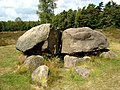
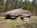
dolmen in the Netherlands  | |||||
| Upload media | |||||
| Instance of | |||||
|---|---|---|---|---|---|
| Part of | |||||
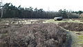
| Location | Emmen, Drenthe, Netherlands | ||||
| Located on street |
| ||||
 | |||||
|
This is a category about rijksmonument number 45383
|
| Address |
|
Media in category "Hunebed D40 in Boswachterij Emmen"
The following 6 files are in this category, out of 6 total.
-
 2005-07 Emmen Hunebed.JPG 2,848 × 2,136; 1.25 MB
-
 D38, D39 en D40.jpg 4,608 × 2,592; 6.42 MB
-
 Hunebed D40 Emmerveld-1.JPG 3,648 × 2,736; 2.01 MB
-
 Hunebed D40 Emmerveld-2.JPG 3,648 × 2,736; 3.84 MB
-
 Hunebed D40 in het-Valtherbosch bij Emmen.jpg 1,296 × 972; 266 KB
-
 Tussen Emmen en Valthe, hunebed foto1 2009-04-25 10.01.JPG 3,072 × 2,304; 3.26 MB


