Category:Hydrographic maps of France
Subcategories
This category has the following 14 subcategories, out of 14 total.
Media in category "Hydrographic maps of France"
The following 127 files are in this category, out of 127 total.
-

-
 26271-La Roche-de-Glun-Sols.png 3,270 × 2,598; 3.54 MB
-
 67-Cours eau 50km.jpg 3,507 × 2,480; 546 KB
-
 67-Cours eau.jpg 3,507 × 2,480; 1.14 MB
-
 68-Cours eau 50km.jpg 3,507 × 2,480; 558 KB
-
 68-Cours eau.jpg 3,507 × 2,480; 1.08 MB
-
 69-Cours eau 50km.jpg 3,507 × 2,480; 580 KB
-
 69-Cours eau.jpg 3,507 × 2,480; 1.51 MB
-
 70-Cours eau 50km.jpg 3,507 × 2,480; 499 KB
-
 70-Cours eau.jpg 3,507 × 2,480; 1.12 MB
-
 72-Cours eau 50km.jpg 3,507 × 2,480; 521 KB
-
 72-Cours eau.jpg 3,507 × 2,480; 1.6 MB
-
 73-Cours eau 50km.jpg 3,507 × 2,480; 478 KB
-
 73-Cours eau.jpg 3,507 × 2,480; 1.3 MB
-
 74-Cours eau 50km.jpg 3,507 × 2,480; 423 KB
-
 74-Cours eau.jpg 3,507 × 2,480; 1.01 MB
-
 77-Cours eau 50km.jpg 3,507 × 2,480; 710 KB
-
 77-Cours eau.jpg 3,507 × 2,480; 1.29 MB
-
 78-Cours eau 50km.jpg 3,507 × 2,480; 581 KB
-
 78-Cours eau.jpg 3,507 × 2,480; 967 KB
-
 79-Cours eau 50km.jpg 3,507 × 2,480; 768 KB
-
 79-Cours eau.jpg 3,507 × 2,480; 1.61 MB
-
 80-Cours eau 50km.jpg 3,507 × 2,480; 599 KB
-
 80-Cours eau.jpg 3,507 × 2,480; 869 KB
-
 81-Cours eau 50km.jpg 3,507 × 2,480; 622 KB
-
 81-Cours eau.jpg 3,507 × 2,480; 1.93 MB
-
 82-Cours eau 50km.jpg 3,507 × 2,480; 592 KB
-
 82-Cours eau.jpg 3,507 × 2,480; 1.51 MB
-
 83-Cours eau 50km.jpg 3,507 × 2,480; 515 KB
-
 83-Cours eau.jpg 3,507 × 2,480; 1.01 MB
-
 84-Cours eau 50km.jpg 3,507 × 2,480; 519 KB
-
 84-Cours eau.jpg 3,507 × 2,480; 1.18 MB
-
 85-Cours eau 50km.jpg 3,507 × 2,480; 534 KB
-
 85-Cours eau.jpg 3,507 × 2,480; 1.25 MB
-
 86-Cours eau 50km.jpg 3,507 × 2,480; 654 KB
-
 86-Cours eau.jpg 3,507 × 2,480; 1.68 MB
-
 89-Cours eau 50km.jpg 3,507 × 2,480; 636 KB
-
 89-Cours eau.jpg 3,507 × 2,480; 1.4 MB
-
 90-Cours eau 50km.jpg 3,507 × 2,480; 401 KB
-
 90-Cours eau.jpg 3,507 × 2,480; 858 KB
-
 91-Cours eau 50km.jpg 3,507 × 2,480; 422 KB
-
 91-Cours eau.jpg 3,507 × 2,480; 770 KB
-
 92-Cours eau 50km.jpg 3,507 × 2,480; 445 KB
-
 92-Cours eau.jpg 3,507 × 2,480; 539 KB
-
 93-Cours eau 50km.jpg 3,507 × 2,480; 447 KB
-
 93-Cours eau.jpg 3,507 × 2,480; 518 KB
-
 94-Cours eau 50km.jpg 3,507 × 2,480; 428 KB
-
 94-Cours eau.jpg 3,507 × 2,480; 528 KB
-
 95-Cours eau 50km.jpg 3,507 × 2,480; 455 KB
-
 95-Cours eau.jpg 3,507 × 2,480; 691 KB
-
-
 Bassins-45.png 5,457 × 3,586; 2.07 MB
-
 Carte potentialité zones humides France.jpg 477 × 574; 173 KB
-
 CE-Aveyron.png 5,457 × 3,543; 2.16 MB
-
 CE-Bec d'Able-Sols.png 5,457 × 3,543; 3.85 MB
-
 CE-Bec d'Able.png 5,457 × 3,543; 2.61 MB
-
 CE-Betz.png 5,457 × 3,543; 2.49 MB
-
 CE-Bezonde.png 5,457 × 3,543; 3.14 MB
-
 CE-Bionne.png 5,457 × 3,543; 2.03 MB
-
 CE-Bonnée.png 5,457 × 3,543; 1.91 MB
-
 CE-Bourillon-Sols.png 5,457 × 3,543; 2.81 MB
-
 CE-Bourillon.png 5,457 × 3,543; 1.85 MB
-
 CE-Canal latéral à la Loire.png 5,457 × 3,543; 2.66 MB
-
 CE-Canne.png 5,457 × 3,543; 2.88 MB
-
 CE-Cheuille-Sols.png 5,457 × 3,543; 3.18 MB
-
 CE-Cheuille.png 5,457 × 3,543; 2.55 MB
-
 CE-Cléry.png 5,457 × 3,543; 3.54 MB
-
 CE-Conie.png 5,457 × 3,543; 2.9 MB
-
 CE-Cosson.png 5,457 × 3,543; 4.69 MB
-
 CE-Dhuy-Sols.png 5,457 × 3,543; 4.75 MB
-
 CE-Dhuy.png 5,457 × 3,543; 3.35 MB
-
 CE-Essonne.png 5,457 × 3,543; 8.12 MB
-
 CE-Fusain.png 5,457 × 3,543; 2.51 MB
-
 CE-Huillard.png 5,457 × 3,543; 2.24 MB
-
 CE-Juine.png 5,457 × 3,543; 4.84 MB
-
 CE-Laye du Nord.png 5,457 × 3,543; 1.81 MB
-
 CE-Lenche.png 5,457 × 3,543; 1.56 MB
-
 CE-Limetin.png 5,457 × 3,543; 2.57 MB
-
 CE-Loiret.png 5,457 × 3,543; 1.46 MB
-
 CE-Marmagne-Sols.png 5,457 × 3,543; 2.33 MB
-
 CE-Marmagne.png 5,457 × 3,543; 1.75 MB
-
 CE-Maurepas.png 5,457 × 3,543; 2.66 MB
-
 CE-Mauve de la Détourbe.png 5,457 × 3,543; 2.58 MB
-
 CE-Milleron.png 5,457 × 3,543; 1.57 MB
-
 CE-Milourdin.png 5,457 × 3,543; 1.65 MB
-
 CE-Notreure-Sols.png 5,457 × 3,543; 5.17 MB
-
 CE-Notreure.png 5,457 × 3,543; 3.79 MB
-
 CE-Ouanne.png 5,457 × 3,543; 4.97 MB
-
 CE-Oussance.png 5,457 × 3,543; 2.42 MB
-
 CE-Ousson-Dhuy-Sols.png 5,457 × 3,543; 2.4 MB
-
 CE-Ousson-Dhuy.png 5,457 × 3,543; 1.78 MB
-
 CE-Ousson-Sols.png 5,457 × 3,543; 2.96 MB
-
 CE-Ousson.png 5,457 × 3,543; 2.29 MB
-
 CE-Petit Ardoux.png 5,457 × 3,543; 1.44 MB
-
 CE-Petit Fusain.png 5,457 × 3,543; 2.68 MB
-
 CE-Pontet.png 5,457 × 3,543; 1.65 MB
-
 CE-Poterie.png 5,457 × 3,543; 1.92 MB
-
 CE-Puiseaux.png 5,457 × 3,543; 3.65 MB
-
 CE-Rigole de Courpalet.png 5,457 × 3,543; 1.73 MB
-
 CE-Rimarde.png 5,457 × 3,543; 3.13 MB
-
 CE-Rolande.png 5,457 × 3,543; 1.97 MB
-
 CE-Ru du Cuivre.png 5,457 × 3,543; 3.35 MB
-
 CE-Ru du Pont Guinant.png 5,457 × 3,543; 1.26 MB
-
 CE-Ru Simon.png 5,457 × 3,543; 1.52 MB
-
 CE-Ru.png 5,457 × 3,543; 1.32 MB
-
 CE-Ruisseau de la Motte Bucy.png 5,457 × 3,543; 1.5 MB
-
 CE-Ruisseau de la Motte.png 5,457 × 3,543; 1.32 MB
-
 CE-Ruisseau de Sainte-Rose.png 5,457 × 3,543; 1.46 MB
-
 CE-Saint-Laurent.png 5,457 × 3,543; 1.72 MB
-
 CE-Sange-Sols.png 5,457 × 3,543; 3.83 MB
-
 CE-Sange.png 5,457 × 3,543; 2.56 MB
-
 CE-Solin.png 5,457 × 3,543; 3.39 MB
-
 CE-Talot.png 5,457 × 3,543; 1.36 MB
-
 CE-Treille.png 5,457 × 3,543; 1.77 MB
-
 CE-Trézée-Sols.png 5,457 × 3,543; 4.21 MB
-
 CE-Trézée.png 5,457 × 3,543; 3.5 MB
-
 CE-Venelle-Sols.png 5,457 × 3,543; 3.37 MB
-
 CE-Venelle.png 5,457 × 3,543; 2.84 MB
-
 CE-Vernisson.png 5,457 × 3,543; 3.67 MB
-
 CE-Vieille Rivière.png 5,457 × 3,543; 1.65 MB
-
 CE-Vézenne.png 5,457 × 3,543; 1.31 MB
-
 Cours d'eau - Aix-les-Bains.png 610 × 518; 266 KB
-
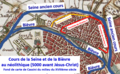
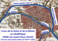 Cours de la Seine et de la Bièvre au néolithique.png 574 × 413; 529 KB
-
 France fluvial.png 2,000 × 1,898; 629 KB
-
 La Combade.jpg 1,121 × 933; 520 KB
-
 QGis-tuto-composeur-routes-hydro.PNG 1,537 × 866; 328 KB
-
 Seine river watershed.png 514 × 490; 11 KB
.jpg)


