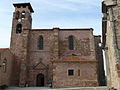
Category:Iglesia de San Pedro, Retortillo de Soria
| Object location | | View all coordinates using: OpenStreetMap |
|---|
 | |||||
| Upload media | |||||
| Instance of | |||||
|---|---|---|---|---|---|
| Location | Retortillo de Soria, Soria Province, Castile and León, Spain | ||||
| Inception |
| ||||
 | |||||
Media in category "Iglesia de San Pedro, Retortillo de Soria"
The following 5 files are in this category, out of 5 total.
-
 IglesiaDeSanPedroRetortilloDeSoria.jpg 3,072 × 2,304; 3.18 MB
-
 PortadaIglesiaDeRetortilloDeSoria.jpg 3,072 × 2,304; 3.44 MB
-
 Retortillo de Soria - 002 (33703278142).jpg 2,848 × 4,288; 5.23 MB
-
 Retortillo de Soria 6.jpg 3,648 × 2,628; 5.63 MB
-
 Retortillo de Soria 7.jpg 3,256 × 2,612; 6.36 MB


.jpg)
