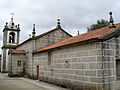
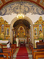
Category:Igreja de São Pedro (Manhouce)
| This building is classified as Sem proteção legal .It is indexed in the SIPA database (Sistema de Informação para o Património Arquitetónico) under the reference 13510. |
| Object location | | View all coordinates using: OpenStreetMap |
|---|
 | |||||
| Upload media | |||||
| Instance of | |||||
|---|---|---|---|---|---|
| Location | Manhouce, São Pedro do Sul, Viseu, Portugal | ||||
| Heritage designation | |||||
| Religion or worldview | |||||
 | |||||
Media in category "Igreja de São Pedro (Manhouce)"
The following 4 files are in this category, out of 4 total.
-
 Igreja Matriz de Manhouce 001.jpg 1,920 × 2,560; 1.47 MB
-
 Igreja Matriz de Manhouce 002.jpg 1,920 × 2,560; 1.22 MB
-
 Igreja Matriz de Manhouce 003.jpg 2,560 × 1,920; 1.11 MB
-
 Igreja Matriz de Manhouce 004.jpg 1,852 × 2,469; 1.03 MB


